

La "8"
A cycling route starting in Séez, Auvergne-Rhône-Alpes, France.
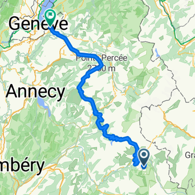
Overview
About this route
Forest route, a must-do at Les Arcs for advanced descenders. From the top of the funicular at Arc 1600, follow the paved road to the Courbaton plateau. A very technical descent on a singletrack through the forest alongside the EDF penstock, down to the Malgovert power plant. Return to the funicular via a paved departmental road along the marshes to the Montrigon bridge.
- -:--
- Duration
- 7.2 km
- Distance
- 42 m
- Ascent
- 861 m
- Descent
- ---
- Avg. speed
- ---
- Max. altitude

Continue with Bikemap
Use, edit, or download this cycling route
You would like to ride La "8" or customize it for your own trip? Here is what you can do with this Bikemap route:
Free features
- Save this route as favorite or in collections
- Copy & plan your own version of this route
- Sync your route with Garmin or Wahoo
Premium features
Free trial for 3 days, or one-time payment. More about Bikemap Premium.
- Navigate this route on iOS & Android
- Export a GPX / KML file of this route
- Create your custom printout (try it for free)
- Download this route for offline navigation
Discover more Premium features.
Get Bikemap PremiumFrom our community
Other popular routes starting in Séez
 Transalpine (11) Bourg St. Maurice - Vijaron
- Distance
- 64.9 km
- Ascent
- 2,025 m
- Descent
- 1,097 m
- Location
- Séez, Auvergne-Rhône-Alpes, France
 p31 Col du Petit Saint-Bernard
- Distance
- 56.4 km
- Ascent
- 1,466 m
- Descent
- 1,524 m
- Location
- Séez, Auvergne-Rhône-Alpes, France
 Iseran
- Distance
- 42.6 km
- Ascent
- 2,037 m
- Descent
- 136 m
- Location
- Séez, Auvergne-Rhône-Alpes, France
 14,15,16) Col de la Madeleine - 2000 m. + Col du Glandon - 1924 m. + Col de la Croix de Fer - 2067 m.
- Distance
- 150.8 km
- Ascent
- 3,319 m
- Descent
- 3,498 m
- Location
- Séez, Auvergne-Rhône-Alpes, France
 Briançon - Arc 2000
- Distance
- 203 km
- Ascent
- 3,914 m
- Descent
- 4,894 m
- Location
- Séez, Auvergne-Rhône-Alpes, France
 La "8"
- Distance
- 7.2 km
- Ascent
- 42 m
- Descent
- 861 m
- Location
- Séez, Auvergne-Rhône-Alpes, France
 Annemasse - Arc 2000
- Distance
- 179.2 km
- Ascent
- 3,155 m
- Descent
- 4,887 m
- Location
- Séez, Auvergne-Rhône-Alpes, France
 Seez - Lanslevillard
- Distance
- 76.7 km
- Ascent
- 1,968 m
- Descent
- 1,399 m
- Location
- Séez, Auvergne-Rhône-Alpes, France
Open it in the app