

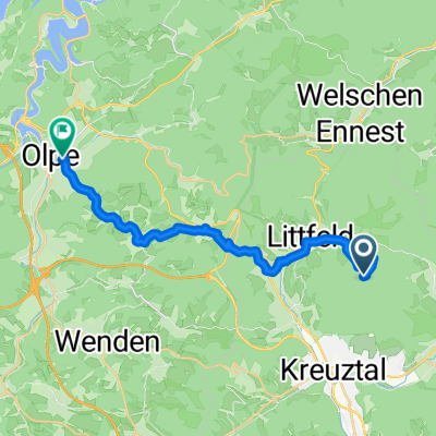
Garminproberunde
A cycling route starting in Kreuztal, North Rhine-Westphalia, Germany.
Overview
About this route
- -:--
- Duration
- 29.8 km
- Distance
- 414 m
- Ascent
- 427 m
- Descent
- ---
- Avg. speed
- 456 m
- Max. altitude

Route quality
Waytypes & surfaces along the route
Waytypes
Quiet road
8.6 km
(29 %)
Road
3.3 km
(11 %)
Surfaces
Paved
16.4 km
(55 %)
Unpaved
3 km
(10 %)
Asphalt
14 km
(47 %)
Paved (undefined)
2.4 km
(8 %)
Continue with Bikemap
Use, edit, or download this cycling route
You would like to ride Garminproberunde or customize it for your own trip? Here is what you can do with this Bikemap route:
Free features
- Save this route as favorite or in collections
- Copy & plan your own version of this route
- Sync your route with Garmin or Wahoo
Premium features
Free trial for 3 days, or one-time payment. More about Bikemap Premium.
- Navigate this route on iOS & Android
- Export a GPX / KML file of this route
- Create your custom printout (try it for free)
- Download this route for offline navigation
Discover more Premium features.
Get Bikemap PremiumFrom our community
Other popular routes starting in Kreuztal
 Garminproberunde
- Distance
- 29.8 km
- Ascent
- 414 m
- Descent
- 427 m
- Location
- Kreuztal, North Rhine-Westphalia, Germany
 Siegerland Radtourenfahren
- Distance
- 148.8 km
- Ascent
- 1,809 m
- Descent
- 1,689 m
- Location
- Kreuztal, North Rhine-Westphalia, Germany
 488. Bigge-Stausee und Nordhelle (Hauptteil)
- Distance
- 97.6 km
- Ascent
- 825 m
- Descent
- 700 m
- Location
- Kreuztal, North Rhine-Westphalia, Germany
 Truppacher Heide, Panzerstrasse
- Distance
- 20.9 km
- Ascent
- 449 m
- Descent
- 446 m
- Location
- Kreuztal, North Rhine-Westphalia, Germany
 wissenrunde
- Distance
- 99 km
- Ascent
- 1,210 m
- Descent
- 1,117 m
- Location
- Kreuztal, North Rhine-Westphalia, Germany
 am Fuße des Kindelsbergs
- Distance
- 15.3 km
- Ascent
- 430 m
- Descent
- 430 m
- Location
- Kreuztal, North Rhine-Westphalia, Germany
 Rundweg 2 ab Krombach
- Distance
- 14.1 km
- Ascent
- 414 m
- Descent
- 375 m
- Location
- Kreuztal, North Rhine-Westphalia, Germany
 kindelsberg - thieringhausen - olpe
- Distance
- 17.8 km
- Ascent
- 255 m
- Descent
- 552 m
- Location
- Kreuztal, North Rhine-Westphalia, Germany
Open it in the app