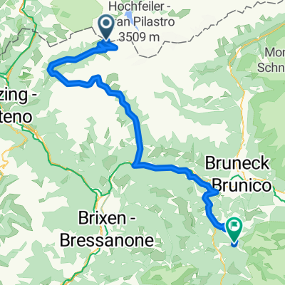
AlpenX Tegernsee-Gardasee 3. Tag
- 53.2 km
- 1,263 m
- 1,464 m
- Ried, Trentino-Alto Adige, Italy
A cycling route starting in Ried, Trentino-Alto Adige, Italy.
Overview
28.6 (Kematen Pfunderer Joch Onach)
um 9 Uhr bei strömenden Regen den 1200 hm Aufstieg gestartet.
1100 mussten wir schieben, da der Forstweg zu steil. Auf der gesamten Tour waren wir die einzigen.
Auf den Almen dann trocken und sehr viele schöne Alpenblumen. Durch einen Bach kamen wir nur ohne Schuhe.
15 °C aber auf unserem höchsten Punkt dem Pfunder Joch (2570 m) nur 5°C und sehr windig.
Dann aber Stress, ein 10m hohes Schneefeld versperrt den Durchgang. Daneben steiler Fels. Umkehren? Niemals, ein kontrollierter Sturz mit Fahrrad im Arm die über 6m hohe Schneewand runter.
Beide Mitfahrer dann über Felsweg mit Hilfe von unten
Weg runter auch über Schneefelder, 500 hm i. W. geschoben.
Dann steil bis 20% bergab parallel zu einer beeindruckenden Schlucht. Bis bald fast leere Straße bis ins Pustertal kam die plötzlich gesperrt War wegen Felsarbeiten.
wir durften dann doch durch. Nach 1800 hm abwärts Ankunft im Pustertal bei gewitzter und starkem Regen.
Nach Warten dann auf die 19 km und 500 hm zum Hotel in Onach verzichtet. Dafür von Vinti bis St. Lorenzens mit dem Zug. Dort holte uns Hotelier in 2 Fuhren ab. 19 Uhr Ankunft.
created this 8 years ago
Continue with Bikemap
You would like to ride Transalp 2017 #5 or customize it for your own trip? Here is what you can do with this Bikemap route:
Free trial for 3 days, or one-time payment. More about Bikemap Premium.
Discover more Premium features.
Get Bikemap PremiumFrom our community
Open it in the app