

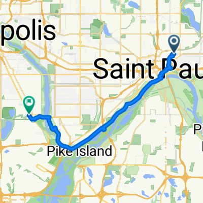
From Saint Paul to Minneapolis
- 19.2 km
- 179 m
- 191 m
- Saint Paul, Minnesota, United States
A cycling route starting in Saint Paul, Minnesota, United States.
Overview
This route is decidedly longer but is far more interesting and faster. Very few stops compared to a cross town route. Take Shepherd Road West along the Mississippi River. You can either ride on the bike path or on the road. Follow Shepherd Rd. past 35E until it becomes East Mississippi River Blvd. Continue on East Mississippi past the Ford Plant. Go under the Ford Pkwy. bridge and make an immediate right hairpin turn up to Ford Pkwy. and cross over the Mississippi on the Ford Bridge. Immediately at the end of the bridge is a path to the right that will take you down to West River Pkwy. Follow West River Pkwy. either on the road or bike path. Pass under Lake Street and continue on. At E.27th Street there is a path up to the Midtown Greenway Bike Trail. Take the bike trail west. At Hiawatha Avenue you can either continue straight ahead and cross with the stop light traffic or proceed on the bike path over the new Martin Sabo bridge. (Very cool at night with blue lights). Continue on the Greenway until you reach Chicago Avenue. Exit up the steps to the street and go north on Chicago to 26th Street and your destination.
Route quality
Cycleway
16.8 km
(77 %)
Road
3.9 km
(18 %)
Paved
12.9 km
(59 %)
Asphalt
11.6 km
(53 %)
Concrete
0.9 km
(4 %)
Route highlights
At this point you can continue across Hiawatha to E. 28th Street with the traffic signals or continue on the bike path to the north and over the Martin Sabo bridge.
Continue with Bikemap
You would like to ride B2B00192 55102>55404viaShepherdRd/MissBlvd/WRiverPkwy/MidtwnGrnway or customize it for your own trip? Here is what you can do with this Bikemap route:
Free trial for 3 days, or one-time payment. More about Bikemap Premium.
Discover more Premium features.
Get Bikemap PremiumFrom our community
Open it in the app


