

20170707_095707.gpx
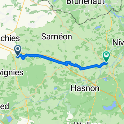
A cycling route starting in Bouvignies, Hauts-de-France, France.
Overview
About this route
TAHUNA track
- -:--
- Duration
- 36.2 km
- Distance
- 64 m
- Ascent
- 69 m
- Descent
- ---
- Avg. speed
- ---
- Max. altitude

Route quality
Waytypes & surfaces along the route
Waytypes
Quiet road
13.4 km
(37 %)
Road
10.1 km
(28 %)
Surfaces
Paved
18.5 km
(51 %)
Unpaved
2.2 km
(6 %)
Asphalt
14.9 km
(41 %)
Concrete
3.6 km
(10 %)
Route highlights
Points of interest along the route
Point of interest after 25 km
YFFKQSSIETJES
Point of interest after 26.2 km
STOP IN BOS
Point of interest after 27.5 km
UITBLAZEN
Continue with Bikemap
Use, edit, or download this cycling route
You would like to ride 20170707_095707.gpx or customize it for your own trip? Here is what you can do with this Bikemap route:
Free features
- Save this route as favorite or in collections
- Copy & plan your own version of this route
- Sync your route with Garmin or Wahoo
Premium features
Free trial for 3 days, or one-time payment. More about Bikemap Premium.
- Navigate this route on iOS & Android
- Export a GPX / KML file of this route
- Create your custom printout (try it for free)
- Download this route for offline navigation
Discover more Premium features.
Get Bikemap PremiumFrom our community
Other popular routes starting in Bouvignies
 20170614_114213.gpx
- Distance
- 26.2 km
- Ascent
- 16 m
- Descent
- 30 m
- Location
- Bouvignies, Hauts-de-France, France
 Trafranvelle 1er jou
- Distance
- 75 km
- Ascent
- 331 m
- Descent
- 243 m
- Location
- Bouvignies, Hauts-de-France, France
 De Chemin de l'Abbé, Marchiennes à Rue du Faubourg de Paris 263, Douai
- Distance
- 39.4 km
- Ascent
- 239 m
- Descent
- 218 m
- Location
- Bouvignies, Hauts-de-France, France
 344–526 Rue des Jardins, Marchiennes à 254 Rue du Curé, Marchiennes
- Distance
- 5.3 km
- Ascent
- 33 m
- Descent
- 32 m
- Location
- Bouvignies, Hauts-de-France, France
 St quentin
- Distance
- 76 km
- Ascent
- 616 m
- Descent
- 506 m
- Location
- Bouvignies, Hauts-de-France, France
 De Rue des Arcins à Grand'place
- Distance
- 14 km
- Ascent
- 0 m
- Descent
- 6 m
- Location
- Bouvignies, Hauts-de-France, France
 Route Nationale, Marchiennes à 1 Zone d'Activités Europe, Orchies
- Distance
- 8.2 km
- Ascent
- 75 m
- Descent
- 54 m
- Location
- Bouvignies, Hauts-de-France, France
 De 22 Impasse de la Pliche, Coutiches à 22 Impasse de la Pliche, Coutiches
- Distance
- 32.4 km
- Ascent
- 160 m
- Descent
- 166 m
- Location
- Bouvignies, Hauts-de-France, France
Open it in the app