
Autour du Colombier
Réauville-Taulignan-Aleyrac
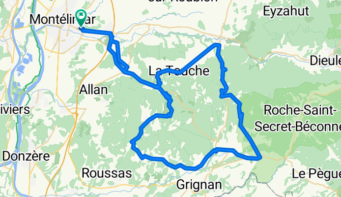
A cycling route starting in Montélimar, Auvergne-Rhône-Alpes, France.
Overview
About this route
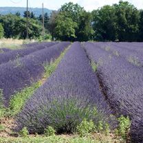
Route through lavender fields avoiding traffic.
- -:--
- Duration
- 71 km
- Distance
- 786 m
- Ascent
- 786 m
- Descent
- ---
- Avg. speed
- ---
- Max. altitude

Part of
Autour du Colombier
3 stages
Route quality
Waytypes & surfaces along the route
Waytypes
Road
35.5 km
(50 %)
Quiet road
8.5 km
(12 %)
Surfaces
Paved
15.6 km
(22 %)
Asphalt
12.8 km
(18 %)
Paved (undefined)
2.8 km
(4 %)
Undefined
55.3 km
(78 %)
Continue with Bikemap
Use, edit, or download this cycling route
You would like to ride Réauville-Taulignan-Aleyrac or customize it for your own trip? Here is what you can do with this Bikemap route:
Free features
- Save this route as favorite or in collections
- Copy & plan your own version of this route
- Sync your route with Garmin or Wahoo
Premium features
Free trial for 3 days, or one-time payment. More about Bikemap Premium.
- Navigate this route on iOS & Android
- Export a GPX / KML file of this route
- Create your custom printout (try it for free)
- Download this route for offline navigation
Discover more Premium features.
Get Bikemap PremiumFrom our community
Other popular routes starting in Montélimar
 Montélimar to Fournès
- Distance
- 87.4 km
- Ascent
- 654 m
- Descent
- 674 m
- Location
- Montélimar, Auvergne-Rhône-Alpes, France
 2016 Ride Day 97 - Montélimar Circle to East
- Distance
- 64.8 km
- Ascent
- 548 m
- Descent
- 548 m
- Location
- Montélimar, Auvergne-Rhône-Alpes, France
 pour aller chez Hervé
- Distance
- 62.3 km
- Ascent
- 520 m
- Descent
- 475 m
- Location
- Montélimar, Auvergne-Rhône-Alpes, France
 Aleyrac
- Distance
- 63.2 km
- Ascent
- 791 m
- Descent
- 791 m
- Location
- Montélimar, Auvergne-Rhône-Alpes, France
 Montelimar - Mont Ventoux
- Distance
- 153.9 km
- Ascent
- 1,895 m
- Descent
- 83 m
- Location
- Montélimar, Auvergne-Rhône-Alpes, France
 Montelimar (col Ardeche)
- Distance
- 55.7 km
- Ascent
- 840 m
- Descent
- 845 m
- Location
- Montélimar, Auvergne-Rhône-Alpes, France
 13. Tag Saint Julien du Gua - Saint Nazaire en Royans
- Distance
- 103.8 km
- Ascent
- 219 m
- Descent
- 132 m
- Location
- Montélimar, Auvergne-Rhône-Alpes, France
 2016 Ride Day 98 - Montélimar to Vesc
- Distance
- 42.6 km
- Ascent
- 613 m
- Descent
- 101 m
- Location
- Montélimar, Auvergne-Rhône-Alpes, France
Open it in the app