
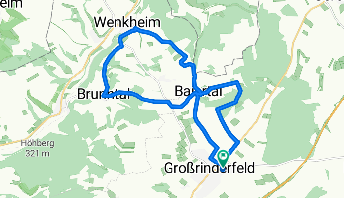
Großrinderfeld/Brunntal
A cycling route starting in Großrinderfeld, Baden-Wurttemberg, Germany.
Overview
About this route
Moderate slopes
Seen many deer and foxes
- -:--
- Duration
- 14.8 km
- Distance
- 320 m
- Ascent
- 320 m
- Descent
- ---
- Avg. speed
- ---
- Max. altitude
Route quality
Waytypes & surfaces along the route
Waytypes
Track
10.3 km
(70 %)
Quiet road
3.7 km
(25 %)
Road
0.7 km
(5 %)
Surfaces
Paved
11.4 km
(77 %)
Unpaved
2.4 km
(16 %)
Asphalt
10.1 km
(68 %)
Gravel
1.3 km
(9 %)
Continue with Bikemap
Use, edit, or download this cycling route
You would like to ride Großrinderfeld/Brunntal or customize it for your own trip? Here is what you can do with this Bikemap route:
Free features
- Save this route as favorite or in collections
- Copy & plan your own version of this route
- Sync your route with Garmin or Wahoo
Premium features
Free trial for 3 days, or one-time payment. More about Bikemap Premium.
- Navigate this route on iOS & Android
- Export a GPX / KML file of this route
- Create your custom printout (try it for free)
- Download this route for offline navigation
Discover more Premium features.
Get Bikemap PremiumFrom our community
Other popular routes starting in Großrinderfeld
 K2811, Großrinderfeld nach Wenkheimer Straße, Großrinderfeld
- Distance
- 6.2 km
- Ascent
- 148 m
- Descent
- 78 m
- Location
- Großrinderfeld, Baden-Wurttemberg, Germany
 Recovered Route
- Distance
- 3.7 km
- Ascent
- 40 m
- Descent
- 59 m
- Location
- Großrinderfeld, Baden-Wurttemberg, Germany
 Krensheim-Ilmspan-Brunntal
- Distance
- 13.2 km
- Ascent
- 177 m
- Descent
- 331 m
- Location
- Großrinderfeld, Baden-Wurttemberg, Germany
 Großrinderfeld/Brunntal
- Distance
- 14.8 km
- Ascent
- 320 m
- Descent
- 320 m
- Location
- Großrinderfeld, Baden-Wurttemberg, Germany
 Hof Baiertal 6, Großrinderfeld nach Eicheler Höhenweg 1, Wertheim
- Distance
- 21 km
- Ascent
- 327 m
- Descent
- 508 m
- Location
- Großrinderfeld, Baden-Wurttemberg, Germany
 Wenkheimer Straße 11, Großrinderfeld nach Martinsstraße 12, Hettstadt
- Distance
- 24.3 km
- Ascent
- 264 m
- Descent
- 326 m
- Location
- Großrinderfeld, Baden-Wurttemberg, Germany
 Weg zu Freund/Grinderfeld nach Schönfeld
- Distance
- 10.6 km
- Ascent
- 141 m
- Descent
- 136 m
- Location
- Großrinderfeld, Baden-Wurttemberg, Germany
 Alemannenstraße 3, Großrinderfeld nach Hauptstraße 40, Tauberbischofsheim
- Distance
- 19.5 km
- Ascent
- 160 m
- Descent
- 300 m
- Location
- Großrinderfeld, Baden-Wurttemberg, Germany
Open it in the app