

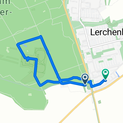
Flugplatz
A cycling route starting in Ober-Olm, Rhineland-Palatinate, Germany.
Overview
About this route
- 57 min
- Duration
- 13.4 km
- Distance
- 85 m
- Ascent
- 85 m
- Descent
- 14 km/h
- Avg. speed
- ---
- Max. altitude

Route quality
Waytypes & surfaces along the route
Waytypes
Quiet road
4.8 km
(36 %)
Track
3.9 km
(29 %)
Surfaces
Paved
11.9 km
(89 %)
Unpaved
0.8 km
(6 %)
Asphalt
11.1 km
(83 %)
Paved (undefined)
0.8 km
(6 %)
Continue with Bikemap
Use, edit, or download this cycling route
You would like to ride Flugplatz or customize it for your own trip? Here is what you can do with this Bikemap route:
Free features
- Save this route as favorite or in collections
- Copy & plan your own version of this route
- Sync your route with Garmin or Wahoo
Premium features
Free trial for 3 days, or one-time payment. More about Bikemap Premium.
- Navigate this route on iOS & Android
- Export a GPX / KML file of this route
- Create your custom printout (try it for free)
- Download this route for offline navigation
Discover more Premium features.
Get Bikemap PremiumFrom our community
Other popular routes starting in Ober-Olm
 Sackgäßchen 6, Ober-Olm nach Römerwall 62, Mainz
- Distance
- 10.7 km
- Ascent
- 59 m
- Descent
- 155 m
- Location
- Ober-Olm, Rhineland-Palatinate, Germany
 Rheinhessen1
- Distance
- 80.5 km
- Ascent
- 511 m
- Descent
- 527 m
- Location
- Ober-Olm, Rhineland-Palatinate, Germany
 OO - Mainz - Nierstein - Wörrstadt - NO
- Distance
- 61 km
- Ascent
- 243 m
- Descent
- 309 m
- Location
- Ober-Olm, Rhineland-Palatinate, Germany
 Nino-Erné-Straße, Mainz to Nino-Erné-Straße, Mainz
- Distance
- 3.9 km
- Ascent
- 25 m
- Descent
- 24 m
- Location
- Ober-Olm, Rhineland-Palatinate, Germany
 Metzgerei Hardt Stadecken Elsheim
- Distance
- 12.3 km
- Ascent
- 86 m
- Descent
- 166 m
- Location
- Ober-Olm, Rhineland-Palatinate, Germany
 74 km Tour
- Distance
- 74.1 km
- Ascent
- 346 m
- Descent
- 346 m
- Location
- Ober-Olm, Rhineland-Palatinate, Germany
 2015: Main-Kinzig
- Distance
- 381.1 km
- Ascent
- 730 m
- Descent
- 730 m
- Location
- Ober-Olm, Rhineland-Palatinate, Germany
 Menzelstraße 16, Mainz nach Menzelstraße 16, Mainz
- Distance
- 33.5 km
- Ascent
- 176 m
- Descent
- 234 m
- Location
- Ober-Olm, Rhineland-Palatinate, Germany
Open it in the app