

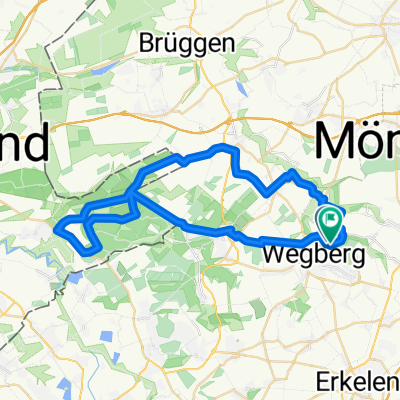
Mühlenroute CLONED FROM ROUTE 353682
A cycling route starting in Wegberg, North Rhine-Westphalia, Germany.
Overview
About this route
Beautiful round through the Wegberg urban area with almost all the mills !! Start: Tüchenbroicher Mill Castle Tüchenbroich Ulrich Chapel In Schönhausen over the Beeckbach across the fields to Gripekoven at the border to Gladbach Holtmühle Mill Busch Mill Molz Mill across the fields to Büch past Raky's villa with pond and Rödger Mill through Dahlheim to the monastery and mill back to Arsbeck ( it goes a bit up) past Klinkum we take at Watern finally the Bischhof Mill and Bocken Mill with.. Have fun!
- -:--
- Duration
- 36.1 km
- Distance
- 83 m
- Ascent
- 82 m
- Descent
- ---
- Avg. speed
- 88 m
- Max. altitude
Route quality
Waytypes & surfaces along the route
Waytypes
Quiet road
18.1 km
(50 %)
Track
7.6 km
(21 %)
Surfaces
Paved
15.9 km
(44 %)
Unpaved
1.4 km
(4 %)
Asphalt
9.8 km
(27 %)
Paved (undefined)
6.1 km
(17 %)
Continue with Bikemap
Use, edit, or download this cycling route
You would like to ride Mühlenroute CLONED FROM ROUTE 353682 or customize it for your own trip? Here is what you can do with this Bikemap route:
Free features
- Save this route as favorite or in collections
- Copy & plan your own version of this route
- Sync your route with Garmin or Wahoo
Premium features
Free trial for 3 days, or one-time payment. More about Bikemap Premium.
- Navigate this route on iOS & Android
- Export a GPX / KML file of this route
- Create your custom printout (try it for free)
- Download this route for offline navigation
Discover more Premium features.
Get Bikemap PremiumFrom our community
Other popular routes starting in Wegberg
 meinweg2
- Distance
- 13.5 km
- Ascent
- 118 m
- Descent
- 153 m
- Location
- Wegberg, North Rhine-Westphalia, Germany
 Siemensweg, Wegberg nach Siemensweg, Wegberg
- Distance
- 44.5 km
- Ascent
- 209 m
- Descent
- 206 m
- Location
- Wegberg, North Rhine-Westphalia, Germany
 Schwalm-Nette Maas Radtour
- Distance
- 62.9 km
- Ascent
- 82 m
- Descent
- 125 m
- Location
- Wegberg, North Rhine-Westphalia, Germany
 Mühlenroute CLONED FROM ROUTE 353682
- Distance
- 36.1 km
- Ascent
- 83 m
- Descent
- 82 m
- Location
- Wegberg, North Rhine-Westphalia, Germany
 NR914: Wegberger Mühlentour
- Distance
- 43 km
- Ascent
- 180 m
- Descent
- 178 m
- Location
- Wegberg, North Rhine-Westphalia, Germany
 ALL-Priorshof-RYStadium
- Distance
- 10.8 km
- Ascent
- 44 m
- Descent
- 64 m
- Location
- Wegberg, North Rhine-Westphalia, Germany
 1.tag
1.tag- Distance
- 24 km
- Ascent
- 102 m
- Descent
- 52 m
- Location
- Wegberg, North Rhine-Westphalia, Germany
 ALL-Priorshof-Voosen-NPark
- Distance
- 7.3 km
- Ascent
- 24 m
- Descent
- 14 m
- Location
- Wegberg, North Rhine-Westphalia, Germany
Open it in the app