

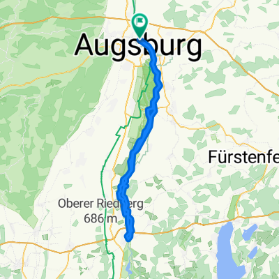
E-Bike Univiertel Augsburg Großaitingen Anhausen Wellenburg
A cycling route starting in Augsburg, Bavaria, Germany.
Overview
About this route
Away from car traffic, this tour goes into the western forests of the Anhauser Valley and back through Wellenburg to the university district of Augsburg.
- -:--
- Duration
- 43.7 km
- Distance
- 263 m
- Ascent
- 263 m
- Descent
- ---
- Avg. speed
- ---
- Max. altitude

Route quality
Waytypes & surfaces along the route
Waytypes
Track
21 km
(48 %)
Path
10.9 km
(25 %)
Surfaces
Paved
24 km
(55 %)
Unpaved
18.8 km
(43 %)
Asphalt
24 km
(55 %)
Gravel
9.6 km
(22 %)
Route highlights
Points of interest along the route
Point of interest after 15.9 km
Wertachstüble, griechisches Restaurant, E-Bike-Ladestation
Point of interest after 25.8 km
Waldgaststätte Engelshof, Biergarten, Sa, So und Feiertags geöffnet.
Point of interest after 35.9 km
Schlossgastätte Wellenburg mit Biergarten
Continue with Bikemap
Use, edit, or download this cycling route
You would like to ride E-Bike Univiertel Augsburg Großaitingen Anhausen Wellenburg or customize it for your own trip? Here is what you can do with this Bikemap route:
Free features
- Save this route as favorite or in collections
- Copy & plan your own version of this route
- Sync your route with Garmin or Wahoo
Premium features
Free trial for 3 days, or one-time payment. More about Bikemap Premium.
- Navigate this route on iOS & Android
- Export a GPX / KML file of this route
- Create your custom printout (try it for free)
- Download this route for offline navigation
Discover more Premium features.
Get Bikemap PremiumFrom our community
Other popular routes starting in Augsburg
 Weldenrundfahrt
- Distance
- 78.6 km
- Ascent
- 481 m
- Descent
- 503 m
- Location
- Augsburg, Bavaria, Germany
 Augsburg-Landsberg-Augsburg
- Distance
- 90.4 km
- Ascent
- 195 m
- Descent
- 194 m
- Location
- Augsburg, Bavaria, Germany
 E-Bike Augsburg Runde
- Distance
- 37.9 km
- Ascent
- 116 m
- Descent
- 116 m
- Location
- Augsburg, Bavaria, Germany
 Augsburgerrunde
- Distance
- 69.9 km
- Ascent
- 344 m
- Descent
- 343 m
- Location
- Augsburg, Bavaria, Germany
 Wertach ab Thelottviertel bis Stausee
- Distance
- 24.8 km
- Ascent
- 137 m
- Descent
- 136 m
- Location
- Augsburg, Bavaria, Germany
 Idyllisches Anhauser Tal – Bismarckturm Neusäß Runde von Augsburg Hauptbahnhof - Idyllisches Anhauser Tal – Bismarckturm Neusäß Runde von Augsburg Hauptbahnhof
- Distance
- 63.3 km
- Ascent
- 339 m
- Descent
- 337 m
- Location
- Augsburg, Bavaria, Germany
 Rundweg Wertach-Lech von Augsburg Süd
- Distance
- 23 km
- Ascent
- 104 m
- Descent
- 106 m
- Location
- Augsburg, Bavaria, Germany
 Augsburg - Westliche Wälder und zurück
- Distance
- 31.3 km
- Ascent
- 444 m
- Descent
- 467 m
- Location
- Augsburg, Bavaria, Germany
Open it in the app