

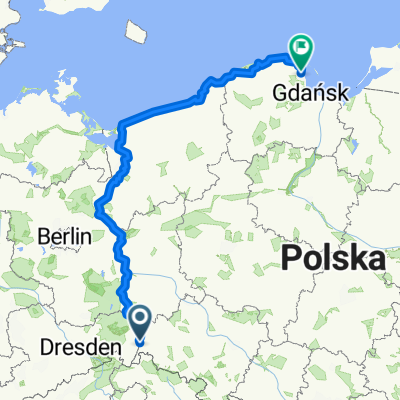
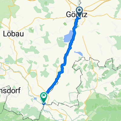
Første dag Görlitz - Leknica
A cycling route starting in Zgorzelec, Lower Silesian Voivodeship, Poland.
Overview
About this route
Langs D 12
- -:--
- Duration
- 66 km
- Distance
- 158 m
- Ascent
- 236 m
- Descent
- ---
- Avg. speed
- ---
- Max. altitude

Route quality
Waytypes & surfaces along the route
Waytypes
Quiet road
16.5 km
(25 %)
Path
15.8 km
(24 %)
Surfaces
Paved
48.2 km
(73 %)
Unpaved
4.6 km
(7 %)
Asphalt
47.5 km
(72 %)
Ground
2.6 km
(4 %)
Continue with Bikemap
Use, edit, or download this cycling route
You would like to ride Første dag Görlitz - Leknica or customize it for your own trip? Here is what you can do with this Bikemap route:
Free features
- Save this route as favorite or in collections
- Copy & plan your own version of this route
- Sync your route with Garmin or Wahoo
Premium features
Free trial for 3 days, or one-time payment. More about Bikemap Premium.
- Navigate this route on iOS & Android
- Export a GPX / KML file of this route
- Create your custom printout (try it for free)
- Download this route for offline navigation
Discover more Premium features.
Get Bikemap PremiumFrom our community
Other popular routes starting in Zgorzelec
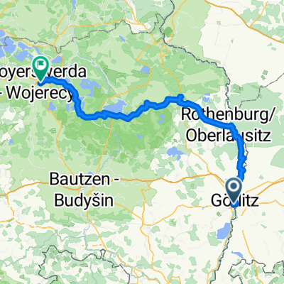 Görlitz - Hoyerswerda 08.08.2025
- Distance
- 105.9 km
- Ascent
- 685 m
- Descent
- 810 m
- Location
- Zgorzelec, Lower Silesian Voivodeship, Poland
 Wypad do Mużaka Dzien 1
- Distance
- 47.7 km
- Ascent
- 745 m
- Descent
- 845 m
- Location
- Zgorzelec, Lower Silesian Voivodeship, Poland
 Dzień 1 Od Zgorzelec do Przewóz
- Distance
- 49 km
- Ascent
- 200 m
- Descent
- 291 m
- Location
- Zgorzelec, Lower Silesian Voivodeship, Poland
 Sybiraków 15, Zgorzelec do Łużycka 33, Zgorzelec
- Distance
- 20.6 km
- Ascent
- 16 m
- Descent
- 33 m
- Location
- Zgorzelec, Lower Silesian Voivodeship, Poland
 From Zgorzelec to Kosakowo
- Distance
- 839 km
- Ascent
- 2,871 m
- Descent
- 3,081 m
- Location
- Zgorzelec, Lower Silesian Voivodeship, Poland
 Der Zwillingsradweg
- Distance
- 274.9 km
- Ascent
- 1,386 m
- Descent
- 1,386 m
- Location
- Zgorzelec, Lower Silesian Voivodeship, Poland
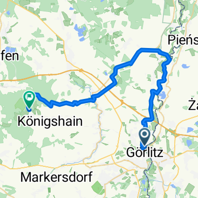 Von Görlitz bis Königshain
- Distance
- 29.9 km
- Ascent
- 350 m
- Descent
- 263 m
- Location
- Zgorzelec, Lower Silesian Voivodeship, Poland
 rondo im Jakoba Böhme, Zgorzelec do Kopaczów
- Distance
- 43.1 km
- Ascent
- 314 m
- Descent
- 287 m
- Location
- Zgorzelec, Lower Silesian Voivodeship, Poland
Open it in the app