

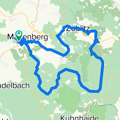
Talsperrenrunde
A cycling route starting in Marienberg, Saxony, Germany.
Overview
About this route
a lap around the drinking water reservoir in Chemnitz
- -:--
- Duration
- 24.2 km
- Distance
- 366 m
- Ascent
- 366 m
- Descent
- ---
- Avg. speed
- ---
- Max. altitude

Continue with Bikemap
Use, edit, or download this cycling route
You would like to ride Talsperrenrunde or customize it for your own trip? Here is what you can do with this Bikemap route:
Free features
- Save this route as favorite or in collections
- Copy & plan your own version of this route
- Sync your route with Garmin or Wahoo
Premium features
Free trial for 3 days, or one-time payment. More about Bikemap Premium.
- Navigate this route on iOS & Android
- Export a GPX / KML file of this route
- Create your custom printout (try it for free)
- Download this route for offline navigation
Discover more Premium features.
Get Bikemap PremiumFrom our community
Other popular routes starting in Marienberg
 Lauta, Lauterbacher Knochen, Jüdenhain, Lauta Pferdegöpel
- Distance
- 10.9 km
- Ascent
- 147 m
- Descent
- 148 m
- Location
- Marienberg, Saxony, Germany
 Talsperrenrunde
- Distance
- 24.2 km
- Ascent
- 366 m
- Descent
- 366 m
- Location
- Marienberg, Saxony, Germany
 Erzgebirge 20180514, Test
- Distance
- 56.4 km
- Ascent
- 575 m
- Descent
- 575 m
- Location
- Marienberg, Saxony, Germany
 Ansprung Cafe
- Distance
- 36.9 km
- Ascent
- 619 m
- Descent
- 624 m
- Location
- Marienberg, Saxony, Germany
 Gerade Fahrt in Marienberg
- Distance
- 18 km
- Ascent
- 358 m
- Descent
- 354 m
- Location
- Marienberg, Saxony, Germany
 Gemütliche Route in Marienberg
- Distance
- 8.8 km
- Ascent
- 104 m
- Descent
- 104 m
- Location
- Marienberg, Saxony, Germany
 Drei Talsperren
- Distance
- 49.8 km
- Ascent
- 1,128 m
- Descent
- 1,127 m
- Location
- Marienberg, Saxony, Germany
 Erzgebirge 20180701
- Distance
- 70.3 km
- Ascent
- 685 m
- Descent
- 685 m
- Location
- Marienberg, Saxony, Germany
Open it in the app