

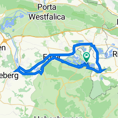
Exten - Silixen - Langenholzhausen -Rundfahrt
A cycling route starting in Rinteln, Lower Saxony, Germany.
Overview
About this route
Nur Asphalt, lange aber moderate Anstiege
- -:--
- Duration
- 28.4 km
- Distance
- 275 m
- Ascent
- 278 m
- Descent
- ---
- Avg. speed
- 269 m
- Max. altitude
Route quality
Waytypes & surfaces along the route
Waytypes
Busy road
9.3 km
(33 %)
Quiet road
6.6 km
(23 %)
Surfaces
Paved
25.6 km
(90 %)
Unpaved
0.2 km
(<1 %)
Asphalt
25.1 km
(88 %)
Concrete
0.5 km
(2 %)
Continue with Bikemap
Use, edit, or download this cycling route
You would like to ride Exten - Silixen - Langenholzhausen -Rundfahrt or customize it for your own trip? Here is what you can do with this Bikemap route:
Free features
- Save this route as favorite or in collections
- Copy & plan your own version of this route
- Sync your route with Garmin or Wahoo
Premium features
Free trial for 3 days, or one-time payment. More about Bikemap Premium.
- Navigate this route on iOS & Android
- Export a GPX / KML file of this route
- Create your custom printout (try it for free)
- Download this route for offline navigation
Discover more Premium features.
Get Bikemap PremiumFrom our community
Other popular routes starting in Rinteln
 Rundweg Rinteln/Möllenbeck/Exten/Rinteln
- Distance
- 15.4 km
- Ascent
- 26 m
- Descent
- 26 m
- Location
- Rinteln, Lower Saxony, Germany
 Wiemerrunde
- Distance
- 47.6 km
- Ascent
- 378 m
- Descent
- 380 m
- Location
- Rinteln, Lower Saxony, Germany
 Am Weseranger 2, Rinteln nach Am Weseranger 2, Rinteln
- Distance
- 20.7 km
- Ascent
- 212 m
- Descent
- 211 m
- Location
- Rinteln, Lower Saxony, Germany
 Rinteln - Hameln
- Distance
- 54.8 km
- Ascent
- 65 m
- Descent
- 64 m
- Location
- Rinteln, Lower Saxony, Germany
 Exten - Silixen - Langenholzhausen -Rundfahrt
- Distance
- 28.4 km
- Ascent
- 275 m
- Descent
- 278 m
- Location
- Rinteln, Lower Saxony, Germany
 WIIDDIEBTRACK12:37 PM
- Distance
- 13.1 km
- Ascent
- 300 m
- Descent
- 299 m
- Location
- Rinteln, Lower Saxony, Germany
 Vom Campingpark Kalletal über Vlotho, Veltheim und Möllenbeck
- Distance
- 34.7 km
- Ascent
- 178 m
- Descent
- 180 m
- Location
- Rinteln, Lower Saxony, Germany
 Rinteln Hameln 1-61km
- Distance
- 60.3 km
- Ascent
- 74 m
- Descent
- 76 m
- Location
- Rinteln, Lower Saxony, Germany
Open it in the app