
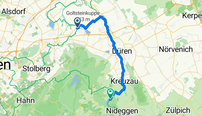
Inden nach Obermaubach MTB
A cycling route starting in Inden, North Rhine-Westphalia, Germany.
Overview
About this route
- -:--
- Duration
- 30 km
- Distance
- 120 m
- Ascent
- 41 m
- Descent
- ---
- Avg. speed
- ---
- Max. altitude

Continue with Bikemap
Use, edit, or download this cycling route
You would like to ride Inden nach Obermaubach MTB or customize it for your own trip? Here is what you can do with this Bikemap route:
Free features
- Save this route as favorite or in collections
- Copy & plan your own version of this route
- Sync your route with Garmin or Wahoo
Premium features
Free trial for 3 days, or one-time payment. More about Bikemap Premium.
- Navigate this route on iOS & Android
- Export a GPX / KML file of this route
- Create your custom printout (try it for free)
- Download this route for offline navigation
Discover more Premium features.
Get Bikemap PremiumFrom our community
Other popular routes starting in Inden
 Laufenburg-Tour
- Distance
- 31 km
- Ascent
- 299 m
- Descent
- 301 m
- Location
- Inden, North Rhine-Westphalia, Germany
 Permanente1 Huchum-Stammeln
- Distance
- 70.2 km
- Ascent
- 106 m
- Descent
- 105 m
- Location
- Inden, North Rhine-Westphalia, Germany
 Radtour LG Lamersdorf
- Distance
- 25.9 km
- Ascent
- 39 m
- Descent
- 38 m
- Location
- Inden, North Rhine-Westphalia, Germany
 Eifel ab Merken
- Distance
- 71.6 km
- Ascent
- 629 m
- Descent
- 629 m
- Location
- Inden, North Rhine-Westphalia, Germany
 Drei Seen Rur Runde
- Distance
- 24.8 km
- Ascent
- 46 m
- Descent
- 44 m
- Location
- Inden, North Rhine-Westphalia, Germany
 Schöntal und der Wald um Laufenburg
- Distance
- 29.2 km
- Ascent
- 320 m
- Descent
- 323 m
- Location
- Inden, North Rhine-Westphalia, Germany
 Inden nach Obermaubach MTB
- Distance
- 30 km
- Ascent
- 120 m
- Descent
- 41 m
- Location
- Inden, North Rhine-Westphalia, Germany
 indeland Radroute 1: Tagebaueinblicke
- Distance
- 27.6 km
- Ascent
- 238 m
- Descent
- 238 m
- Location
- Inden, North Rhine-Westphalia, Germany
Open it in the app