

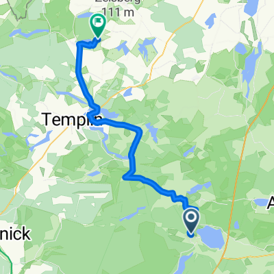
20170614_175027.gpx
A cycling route starting in Joachimsthal, Brandenburg, Germany.
Overview
About this route
TAHUNA track
- -:--
- Duration
- 15.6 km
- Distance
- 70 m
- Ascent
- 67 m
- Descent
- ---
- Avg. speed
- ---
- Max. altitude
Route quality
Waytypes & surfaces along the route
Waytypes
Quiet road
4.7 km
(30 %)
Path
3.4 km
(22 %)
Surfaces
Paved
12.4 km
(79 %)
Unpaved
0.2 km
(1 %)
Asphalt
11.7 km
(75 %)
Concrete
0.6 km
(4 %)
Continue with Bikemap
Use, edit, or download this cycling route
You would like to ride 20170614_175027.gpx or customize it for your own trip? Here is what you can do with this Bikemap route:
Free features
- Save this route as favorite or in collections
- Copy & plan your own version of this route
- Sync your route with Garmin or Wahoo
Premium features
Free trial for 3 days, or one-time payment. More about Bikemap Premium.
- Navigate this route on iOS & Android
- Export a GPX / KML file of this route
- Create your custom printout (try it for free)
- Download this route for offline navigation
Discover more Premium features.
Get Bikemap PremiumFrom our community
Other popular routes starting in Joachimsthal
 Rund um den Werbellinsee
- Distance
- 26.5 km
- Ascent
- 206 m
- Descent
- 206 m
- Location
- Joachimsthal, Brandenburg, Germany
 Templiner Straße, Joachimsthal nach Stabeshöhe, Boitzenburger Land
- Distance
- 46.3 km
- Ascent
- 338 m
- Descent
- 328 m
- Location
- Joachimsthal, Brandenburg, Germany
 19 I Werbellinsee - Üdersee/Finowfurt
- Distance
- 15.7 km
- Ascent
- 120 m
- Descent
- 142 m
- Location
- Joachimsthal, Brandenburg, Germany
 Joachimsthal Angermünde Chorin
- Distance
- 87.3 km
- Ascent
- 243 m
- Descent
- 243 m
- Location
- Joachimsthal, Brandenburg, Germany
 Berlin - Müritz II
- Distance
- 54.1 km
- Ascent
- 196 m
- Descent
- 166 m
- Location
- Joachimsthal, Brandenburg, Germany
 Barnim Tour
- Distance
- 70.3 km
- Ascent
- 256 m
- Descent
- 256 m
- Location
- Joachimsthal, Brandenburg, Germany
 Werbellinsee Waldstrecke
- Distance
- 30.3 km
- Ascent
- 232 m
- Descent
- 232 m
- Location
- Joachimsthal, Brandenburg, Germany
 tour durch die uckermark
- Distance
- 119.4 km
- Ascent
- 205 m
- Descent
- 204 m
- Location
- Joachimsthal, Brandenburg, Germany
Open it in the app