

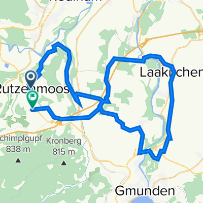
Hongar
A cycling route starting in Aurach am Hongar, Upper Austria, Austria.
Overview
About this route
- -:--
- Duration
- 16.3 km
- Distance
- 447 m
- Ascent
- 423 m
- Descent
- ---
- Avg. speed
- ---
- Max. altitude

Route quality
Waytypes & surfaces along the route
Waytypes
Track
9.9 km
(61 %)
Quiet road
3.1 km
(19 %)
Surfaces
Paved
4.6 km
(28 %)
Unpaved
11.4 km
(70 %)
Gravel
11.2 km
(69 %)
Asphalt
4.2 km
(26 %)
Route highlights
Points of interest along the route
Point of interest after 7.3 km
Point of interest after 9.7 km
Point of interest after 11.5 km
Continue with Bikemap
Use, edit, or download this cycling route
You would like to ride Hongar or customize it for your own trip? Here is what you can do with this Bikemap route:
Free features
- Save this route as favorite or in collections
- Copy & plan your own version of this route
- Sync your route with Garmin or Wahoo
Premium features
Free trial for 3 days, or one-time payment. More about Bikemap Premium.
- Navigate this route on iOS & Android
- Export a GPX / KML file of this route
- Create your custom printout (try it for free)
- Download this route for offline navigation
Discover more Premium features.
Get Bikemap PremiumFrom our community
Other popular routes starting in Aurach am Hongar
 Runde Ruthenmoos - Hinterbuch - Wankham
- Distance
- 11 km
- Ascent
- 118 m
- Descent
- 117 m
- Location
- Aurach am Hongar, Upper Austria, Austria
 Route nach B120 2, Gmunden
- Distance
- 14.9 km
- Ascent
- 361 m
- Descent
- 725 m
- Location
- Aurach am Hongar, Upper Austria, Austria
 Laakirchen Runde
- Distance
- 36.3 km
- Ascent
- 495 m
- Descent
- 577 m
- Location
- Aurach am Hongar, Upper Austria, Austria
 Fisch Lambach Waldweg
- Distance
- 38.8 km
- Ascent
- 596 m
- Descent
- 689 m
- Location
- Aurach am Hongar, Upper Austria, Austria
 Hongar
- Distance
- 16.3 km
- Ascent
- 447 m
- Descent
- 423 m
- Location
- Aurach am Hongar, Upper Austria, Austria
 Salzkammergutradweg Teil 2
- Distance
- 112.4 km
- Ascent
- 549 m
- Descent
- 616 m
- Location
- Aurach am Hongar, Upper Austria, Austria
 Quer durchs Salzkammergut
- Distance
- 88.5 km
- Ascent
- 2,476 m
- Descent
- 2,477 m
- Location
- Aurach am Hongar, Upper Austria, Austria
 Grünau im almtal
- Distance
- 87.1 km
- Ascent
- 637 m
- Descent
- 643 m
- Location
- Aurach am Hongar, Upper Austria, Austria
Open it in the app