
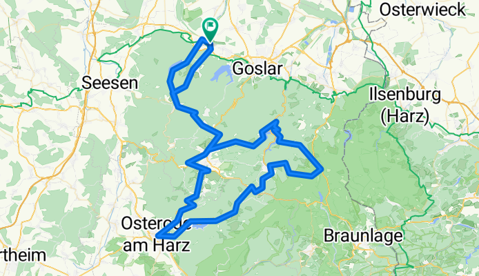
Drei Talsperren
A cycling route starting in Langelsheim, Lower Saxony, Germany.
Overview
About this route
- -:--
- Duration
- 118.4 km
- Distance
- 1,448 m
- Ascent
- 1,448 m
- Descent
- ---
- Avg. speed
- ---
- Max. altitude

Route photos


Route quality
Waytypes & surfaces along the route
Waytypes
Road
15.4 km
(13 %)
Track
11.8 km
(10 %)
Surfaces
Paved
111.3 km
(94 %)
Unpaved
2.4 km
(2 %)
Asphalt
111.3 km
(94 %)
Unpaved (undefined)
1.2 km
(1 %)
Continue with Bikemap
Use, edit, or download this cycling route
You would like to ride Drei Talsperren or customize it for your own trip? Here is what you can do with this Bikemap route:
Free features
- Save this route as favorite or in collections
- Copy & plan your own version of this route
- Split it into stages to create a multi-day tour
- Sync your route with Garmin or Wahoo
Premium features
Free trial for 3 days, or one-time payment. More about Bikemap Premium.
- Navigate this route on iOS & Android
- Export a GPX / KML file of this route
- Create your custom printout (try it for free)
- Download this route for offline navigation
Discover more Premium features.
Get Bikemap PremiumFrom our community
Other popular routes starting in Langelsheim
 Innerstetal- und Granetalsperre
- Distance
- 39.8 km
- Ascent
- 346 m
- Descent
- 341 m
- Location
- Langelsheim, Lower Saxony, Germany
 Rundfahrt Innerste
- Distance
- 23.7 km
- Ascent
- 544 m
- Descent
- 544 m
- Location
- Langelsheim, Lower Saxony, Germany
 Jerstedt - Granetalsperre - Grauhöfer Holz
- Distance
- 35.8 km
- Ascent
- 394 m
- Descent
- 375 m
- Location
- Langelsheim, Lower Saxony, Germany
 Tour de Wade - Harz KA Training
- Distance
- 80.6 km
- Ascent
- 1,095 m
- Descent
- 1,002 m
- Location
- Langelsheim, Lower Saxony, Germany
 15 Altarklippen- Langelith-Borbergsbach
- Distance
- 15.2 km
- Ascent
- 337 m
- Descent
- 347 m
- Location
- Langelsheim, Lower Saxony, Germany
 Eröffnungstour HARZ 2013
- Distance
- 39.1 km
- Ascent
- 790 m
- Descent
- 793 m
- Location
- Langelsheim, Lower Saxony, Germany
 Langelsheim-Hornburg
- Distance
- 58.7 km
- Ascent
- 383 m
- Descent
- 383 m
- Location
- Langelsheim, Lower Saxony, Germany
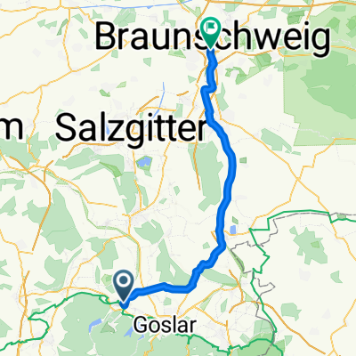 Braunschweig
- Distance
- 51.2 km
- Ascent
- 127 m
- Descent
- 252 m
- Location
- Langelsheim, Lower Saxony, Germany
Open it in the app