

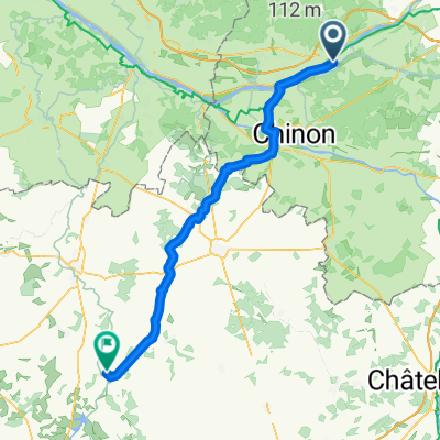
Bréhémont-CandesStMartin
A cycling route starting in Cheillé, Centre-Val de Loire, France.
Overview
About this route
- -:--
- Duration
- 33.2 km
- Distance
- 30 m
- Ascent
- 29 m
- Descent
- ---
- Avg. speed
- ---
- Max. altitude
Route quality
Waytypes & surfaces along the route
Waytypes
Quiet road
15.9 km
(48 %)
Track
10 km
(30 %)
Surfaces
Paved
10.6 km
(32 %)
Unpaved
9.3 km
(28 %)
Asphalt
9.3 km
(28 %)
Gravel
8.3 km
(25 %)
Continue with Bikemap
Use, edit, or download this cycling route
You would like to ride Bréhémont-CandesStMartin or customize it for your own trip? Here is what you can do with this Bikemap route:
Free features
- Save this route as favorite or in collections
- Copy & plan your own version of this route
- Sync your route with Garmin or Wahoo
Premium features
Free trial for 3 days, or one-time payment. More about Bikemap Premium.
- Navigate this route on iOS & Android
- Export a GPX / KML file of this route
- Create your custom printout (try it for free)
- Download this route for offline navigation
Discover more Premium features.
Get Bikemap PremiumFrom our community
Other popular routes starting in Cheillé
 FR1 Cheillé - Trèves
- Distance
- 79.9 km
- Ascent
- 489 m
- Descent
- 469 m
- Location
- Cheillé, Centre-Val de Loire, France
 Bréhémont-CandesStMartin
- Distance
- 33.2 km
- Ascent
- 30 m
- Descent
- 29 m
- Location
- Cheillé, Centre-Val de Loire, France
 12. Bréhémont - Airvault
- Distance
- 73.2 km
- Ascent
- 363 m
- Descent
- 305 m
- Location
- Cheillé, Centre-Val de Loire, France
 2025.9 Rivarennes - Montsoreau
- Distance
- 34.9 km
- Ascent
- 114 m
- Descent
- 115 m
- Location
- Cheillé, Centre-Val de Loire, France
 Frankrijk
- Distance
- 1,010.1 km
- Ascent
- 2,182 m
- Descent
- 2,176 m
- Location
- Cheillé, Centre-Val de Loire, France
 Le Stade 7, Bréhémont nach Rue du Château 2, Chenonceaux
- Distance
- 62.6 km
- Ascent
- 242 m
- Descent
- 211 m
- Location
- Cheillé, Centre-Val de Loire, France
 Da 56 Route de Langeais, Azay-le-Rideau a 60bis Route de Langeais, Azay-le-Rideau
- Distance
- 0.3 km
- Ascent
- 0 m
- Descent
- 0 m
- Location
- Cheillé, Centre-Val de Loire, France
 Tour_2018_Tag11
- Distance
- 115.2 km
- Ascent
- 257 m
- Descent
- 274 m
- Location
- Cheillé, Centre-Val de Loire, France
Open it in the app