
10fb4
A cycling route starting in Agăş, Bacău County, Romania.
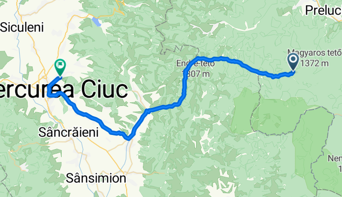
Overview
About this route
- -:--
- Duration
- 47.1 km
- Distance
- 534 m
- Ascent
- 621 m
- Descent
- ---
- Avg. speed
- ---
- Max. altitude
Route quality
Waytypes & surfaces along the route
Waytypes
Quiet road
25.4 km
(54 %)
Road
1.4 km
(3 %)
Surfaces
Paved
20.7 km
(44 %)
Unpaved
25.9 km
(55 %)
Gravel
22.6 km
(48 %)
Asphalt
20.7 km
(44 %)
Continue with Bikemap
Use, edit, or download this cycling route
You would like to ride 10fb4 or customize it for your own trip? Here is what you can do with this Bikemap route:
Free features
- Save this route as favorite or in collections
- Copy & plan your own version of this route
- Sync your route with Garmin or Wahoo
Premium features
Free trial for 3 days, or one-time payment. More about Bikemap Premium.
- Navigate this route on iOS & Android
- Export a GPX / KML file of this route
- Create your custom printout (try it for free)
- Download this route for offline navigation
Discover more Premium features.
Get Bikemap PremiumFrom our community
Other popular routes starting in Agăş
 MTB SULTA-COSNEA-VALEA TROTUSULUI-FAGETEL-LUNCA DE SUS
- Distance
- 41.5 km
- Ascent
- 858 m
- Descent
- 504 m
- Location
- Agăş, Bacău County, Romania
 Catrusa - Sanzieni - Carpineni - Valea Uzului - Darmanesti - Comanesti - Cosnea
- Distance
- 123.3 km
- Ascent
- 1,323 m
- Descent
- 1,230 m
- Location
- Agăş, Bacău County, Romania
 prop. sulta - lacul frumoasa
- Distance
- 30.7 km
- Ascent
- 804 m
- Descent
- 490 m
- Location
- Agăş, Bacău County, Romania
 Strada Sulței, Sulţa to Pálos
- Distance
- 33.6 km
- Ascent
- 909 m
- Descent
- 586 m
- Location
- Agăş, Bacău County, Romania
 10fb4
10fb4- Distance
- 47.1 km
- Ascent
- 534 m
- Descent
- 621 m
- Location
- Agăş, Bacău County, Romania
 MTB AGĂȘ-COȘNEA-FRUMOASA
- Distance
- 33.6 km
- Ascent
- 795 m
- Descent
- 474 m
- Location
- Agăş, Bacău County, Romania
 AGAS-SULTA-COSNEA-MUNTELE LUNG-MUNTELE NILENC-MUNTELE ALB-VALEA BOROS
- Distance
- 51.8 km
- Ascent
- 935 m
- Descent
- 634 m
- Location
- Agăş, Bacău County, Romania
 VALEA SULTEI-COSNEA-VALEA CIOBANUSULUI
- Distance
- 61.1 km
- Ascent
- 1,204 m
- Descent
- 1,209 m
- Location
- Agăş, Bacău County, Romania
Open it in the app