
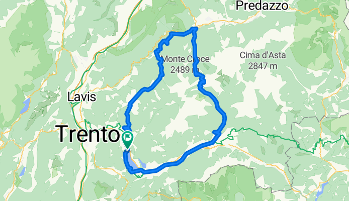
CALDONAZZO-MANGHEN-BEDOLLO
A cycling route starting in Pergine Valsugana, Trentino-Alto Adige, Italy.
Overview
About this route
Calondazzo Borgo V cycle path. All on asphalt. Then at the junction for Segonzano, turn left towards Bedollo-Baselga di Pinè.
- -:--
- Duration
- 108.8 km
- Distance
- 2,025 m
- Ascent
- 2,023 m
- Descent
- ---
- Avg. speed
- ---
- Max. altitude

Route quality
Waytypes & surfaces along the route
Waytypes
Quiet road
13.1 km
(12 %)
Cycleway
7.6 km
(7 %)
Surfaces
Paved
95.8 km
(88 %)
Asphalt
95.8 km
(88 %)
Undefined
13.1 km
(12 %)
Continue with Bikemap
Use, edit, or download this cycling route
You would like to ride CALDONAZZO-MANGHEN-BEDOLLO or customize it for your own trip? Here is what you can do with this Bikemap route:
Free features
- Save this route as favorite or in collections
- Copy & plan your own version of this route
- Split it into stages to create a multi-day tour
- Sync your route with Garmin or Wahoo
Premium features
Free trial for 3 days, or one-time payment. More about Bikemap Premium.
- Navigate this route on iOS & Android
- Export a GPX / KML file of this route
- Create your custom printout (try it for free)
- Download this route for offline navigation
Discover more Premium features.
Get Bikemap PremiumFrom our community
Other popular routes starting in Pergine Valsugana
 VS_ Pergine - Bassano del Grappa
- Distance
- 85.4 km
- Ascent
- 193 m
- Descent
- 552 m
- Location
- Pergine Valsugana, Trentino-Alto Adige, Italy
 CALDONAZZO-MANGHEN-BEDOLLO
- Distance
- 108.8 km
- Ascent
- 2,025 m
- Descent
- 2,023 m
- Location
- Pergine Valsugana, Trentino-Alto Adige, Italy
 v277 ciclabile Valsugana - PERGINE - BASSANO (pisteciclabili)
- Distance
- 82.1 km
- Ascent
- 147 m
- Descent
- 501 m
- Location
- Pergine Valsugana, Trentino-Alto Adige, Italy
 Giro della Marzola
- Distance
- 24.9 km
- Ascent
- 978 m
- Descent
- 978 m
- Location
- Pergine Valsugana, Trentino-Alto Adige, Italy
 Pergine - Menador - Luserna - Carbonare - Fiorentini Carbonare - Campregheri - Pergine
- Distance
- 99.5 km
- Ascent
- 1,766 m
- Descent
- 1,766 m
- Location
- Pergine Valsugana, Trentino-Alto Adige, Italy
 Giro del castello e lago (via Tenna)
- Distance
- 25.4 km
- Ascent
- 255 m
- Descent
- 253 m
- Location
- Pergine Valsugana, Trentino-Alto Adige, Italy
 giro dei laghi 2
- Distance
- 23.4 km
- Ascent
- 520 m
- Descent
- 515 m
- Location
- Pergine Valsugana, Trentino-Alto Adige, Italy
 20191005 Valsugana da S.Cristoforo a Novaledo
- Distance
- 16.2 km
- Ascent
- 59 m
- Descent
- 90 m
- Location
- Pergine Valsugana, Trentino-Alto Adige, Italy
Open it in the app