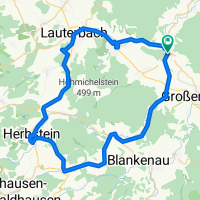
Zwischen Rhön und Vogelsberg
A cycling route starting in Bad Salzschlirf, Hesse, Germany.
Overview
About this route
Schlitz-Bad Salzschlirf-Eichenau-Großenlüder-Lütterz-Bimbach-Besges-Oberrode (straight across the intersection through the village and steep asphalt path into the forest - don't worry, the path continues :-) )-Giesel-Neuhof-Rommerz-Hauswurz-Weidenau-Richlos-Günzenau-Jossa-Poppenrod-Hosenfeld (at the roundabout take the narrow road on the left. Take the asphalt path over the mountain) - Zahmen-Heisters-Steinfurt-Altenschlirf-Schlechtenwegen-Stockhausen-Müs-Bad Salzschlirf-Schlitz
- -:--
- Duration
- 111 km
- Distance
- 1,192 m
- Ascent
- 1,093 m
- Descent
- ---
- Avg. speed
- 514 m
- Max. altitude
Route quality
Waytypes & surfaces along the route
Waytypes
Road
22.2 km
(20 %)
Track
16.6 km
(15 %)
Surfaces
Paved
71 km
(64 %)
Unpaved
16.6 km
(15 %)
Asphalt
69.9 km
(63 %)
Gravel
8.9 km
(8 %)
Continue with Bikemap
Use, edit, or download this cycling route
You would like to ride Zwischen Rhön und Vogelsberg or customize it for your own trip? Here is what you can do with this Bikemap route:
Free features
- Save this route as favorite or in collections
- Copy & plan your own version of this route
- Split it into stages to create a multi-day tour
- Sync your route with Garmin or Wahoo
Premium features
Free trial for 3 days, or one-time payment. More about Bikemap Premium.
- Navigate this route on iOS & Android
- Export a GPX / KML file of this route
- Create your custom printout (try it for free)
- Download this route for offline navigation
Discover more Premium features.
Get Bikemap PremiumFrom our community
Other popular routes starting in Bad Salzschlirf
- Skiroute_Landenhausen
- Distance
- 0.4 km
- Ascent
- 0 m
- Descent
- 50 m
- Location
- Bad Salzschlirf, Hesse, Germany
- shuq-club-mountainbike-Runde
- Distance
- 51.4 km
- Ascent
- 796 m
- Descent
- 796 m
- Location
- Bad Salzschlirf, Hesse, Germany
- Bahntrasse Hessen Bad Salzschlirf – Schlitz – Niederjossa 24km
- Distance
- 23.7 km
- Ascent
- 72 m
- Descent
- 108 m
- Location
- Bad Salzschlirf, Hesse, Germany
- Bad Salzschlirf-Bad Sooden Allensdorf
- Distance
- 105.2 km
- Ascent
- 273 m
- Descent
- 370 m
- Location
- Bad Salzschlirf, Hesse, Germany
- Landenhausen-Schlitz-Fulda-Landenhausen
- Distance
- 43.1 km
- Ascent
- 399 m
- Descent
- 386 m
- Location
- Bad Salzschlirf, Hesse, Germany
- Kindertour 4 bis Friedlos
- Distance
- 48.6 km
- Ascent
- 106 m
- Descent
- 143 m
- Location
- Bad Salzschlirf, Hesse, Germany
- Landenhausen-Schotten-Runde
- Distance
- 80.2 km
- Ascent
- 1,276 m
- Descent
- 1,185 m
- Location
- Bad Salzschlirf, Hesse, Germany
- Bad Salzschlirf 1
- Distance
- 51 km
- Ascent
- 516 m
- Descent
- 516 m
- Location
- Bad Salzschlirf, Hesse, Germany
Open it in the app