

Csongrádi városnézés
Át a piroson! (Piroskaváros)
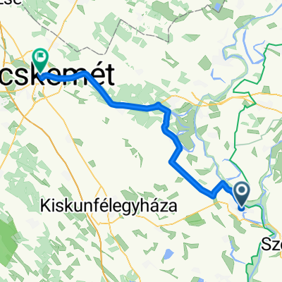
A cycling route starting in Csongrád, Csongrád megye, Hungary.
Overview
About this route
Tisza Dam – Wooden Bridge – Flood Memorial Bell – Industrial Park – St. Joseph – Church – Small Market (7 km)
Photos: Gábor Révész; Csongrádi Értéktár; Facebook
- -:--
- Duration
- 5.7 km
- Distance
- 12 m
- Ascent
- 15 m
- Descent
- ---
- Avg. speed
- ---
- Max. altitude

Part of
Csongrádi városnézés
5 stages
Route quality
Waytypes & surfaces along the route
Waytypes
Access road
2.7 km
(47 %)
Quiet road
1.1 km
(20 %)
Surfaces
Paved
4.6 km
(81 %)
Asphalt
4.2 km
(74 %)
Wood
0.4 km
(7 %)
Undefined
1.1 km
(19 %)
Continue with Bikemap
Use, edit, or download this cycling route
You would like to ride Át a piroson! (Piroskaváros) or customize it for your own trip? Here is what you can do with this Bikemap route:
Free features
- Save this route as favorite or in collections
- Copy & plan your own version of this route
- Sync your route with Garmin or Wahoo
Premium features
Free trial for 3 days, or one-time payment. More about Bikemap Premium.
- Navigate this route on iOS & Android
- Export a GPX / KML file of this route
- Create your custom printout (try it for free)
- Download this route for offline navigation
Discover more Premium features.
Get Bikemap PremiumFrom our community
Other popular routes starting in Csongrád
 Ópusztaszer-nagykör
- Distance
- 71.8 km
- Ascent
- 18 m
- Descent
- 16 m
- Location
- Csongrád, Csongrád megye, Hungary
 Csongrád - Szeged (Ópusztaszer, Mindszent)
- Distance
- 77.5 km
- Ascent
- 128 m
- Descent
- 132 m
- Location
- Csongrád, Csongrád megye, Hungary
 Csongrád - Szolnok
- Distance
- 76.3 km
- Ascent
- 82 m
- Descent
- 79 m
- Location
- Csongrád, Csongrád megye, Hungary
 Csongrád
- Distance
- 47.7 km
- Ascent
- 16 m
- Descent
- 17 m
- Location
- Csongrád, Csongrád megye, Hungary
 Csongrád körtúra
- Distance
- 25.1 km
- Ascent
- 21 m
- Descent
- 21 m
- Location
- Csongrád, Csongrád megye, Hungary
 Csongrád vasútállomás- Szentes vasútállomás
- Distance
- 29.1 km
- Ascent
- 31 m
- Descent
- 29 m
- Location
- Csongrád, Csongrád megye, Hungary
 Hungary Day 14
- Distance
- 31.1 km
- Ascent
- 4 m
- Descent
- 10 m
- Location
- Csongrád, Csongrád megye, Hungary
 Túra 2020 - 4. nap
- Distance
- 53.8 km
- Ascent
- 46 m
- Descent
- 16 m
- Location
- Csongrád, Csongrád megye, Hungary
Open it in the app