
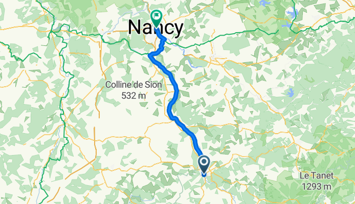
mosel17-2
A cycling route starting in Chantraine, Grand Est, France.
Overview
About this route
Épinal-Nancy
- -:--
- Duration
- 77.4 km
- Distance
- 66 m
- Ascent
- 202 m
- Descent
- ---
- Avg. speed
- ---
- Max. altitude

Route quality
Waytypes & surfaces along the route
Waytypes
Path
36.4 km
(47 %)
Access road
28.6 km
(37 %)
Surfaces
Paved
69.6 km
(90 %)
Unpaved
5.4 km
(7 %)
Asphalt
68.1 km
(88 %)
Gravel
2.3 km
(3 %)
Continue with Bikemap
Use, edit, or download this cycling route
You would like to ride mosel17-2 or customize it for your own trip? Here is what you can do with this Bikemap route:
Free features
- Save this route as favorite or in collections
- Copy & plan your own version of this route
- Sync your route with Garmin or Wahoo
Premium features
Free trial for 3 days, or one-time payment. More about Bikemap Premium.
- Navigate this route on iOS & Android
- Export a GPX / KML file of this route
- Create your custom printout (try it for free)
- Download this route for offline navigation
Discover more Premium features.
Get Bikemap PremiumFrom our community
Other popular routes starting in Chantraine
 Epinal - Conflandey
- Distance
- 99.5 km
- Ascent
- 232 m
- Descent
- 348 m
- Location
- Chantraine, Grand Est, France
 Bbis_19juin_Mirecourt
- Distance
- 88.1 km
- Ascent
- 638 m
- Descent
- 644 m
- Location
- Chantraine, Grand Est, France
 mosel17-2
- Distance
- 77.4 km
- Ascent
- 66 m
- Descent
- 202 m
- Location
- Chantraine, Grand Est, France
 140726, 5. Etappe, Epinal-Bussang
- Distance
- 63.2 km
- Ascent
- 358 m
- Descent
- 89 m
- Location
- Chantraine, Grand Est, France
 BIS-Les Vosges Saonoises-20017122
- Distance
- 68.8 km
- Ascent
- 578 m
- Descent
- 578 m
- Location
- Chantraine, Grand Est, France
 Tour de France 2010 Etape 6 (fake...)
- Distance
- 177.8 km
- Ascent
- 3,963 m
- Descent
- 3,641 m
- Location
- Chantraine, Grand Est, France
 lundi pâque
- Distance
- 15.6 km
- Ascent
- 521 m
- Descent
- 521 m
- Location
- Chantraine, Grand Est, France
 Tag 3: Epinal - Nancy
- Distance
- 79.5 km
- Ascent
- 202 m
- Descent
- 314 m
- Location
- Chantraine, Grand Est, France
Open it in the app