

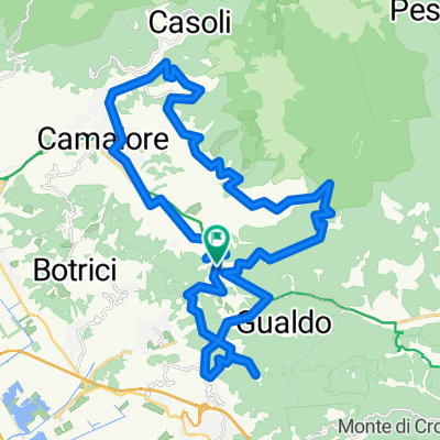
Fiano di Pescaglia
A cycling route starting in Stiava, Tuscany, Italy.
Overview
About this route
- 8 h 7 min
- Duration
- 60.5 km
- Distance
- 957 m
- Ascent
- 876 m
- Descent
- 7.5 km/h
- Avg. speed
- ---
- Max. altitude

Route quality
Waytypes & surfaces along the route
Waytypes
Road
15.1 km
(25 %)
Quiet road
9.1 km
(15 %)
Surfaces
Paved
43 km
(71 %)
Asphalt
43 km
(71 %)
Undefined
17.5 km
(29 %)
Continue with Bikemap
Use, edit, or download this cycling route
You would like to ride Fiano di Pescaglia or customize it for your own trip? Here is what you can do with this Bikemap route:
Free features
- Save this route as favorite or in collections
- Copy & plan your own version of this route
- Sync your route with Garmin or Wahoo
Premium features
Free trial for 3 days, or one-time payment. More about Bikemap Premium.
- Navigate this route on iOS & Android
- Export a GPX / KML file of this route
- Create your custom printout (try it for free)
- Download this route for offline navigation
Discover more Premium features.
Get Bikemap PremiumFrom our community
Other popular routes starting in Stiava
 Da Via delle Selvarelle 330/B, Massarosa a Piazza San Bernardino 1, Camaiore
- Distance
- 7.6 km
- Ascent
- 230 m
- Descent
- 224 m
- Location
- Stiava, Tuscany, Italy
 QUESTA è DURA
- Distance
- 37.2 km
- Ascent
- 1,040 m
- Descent
- 1,040 m
- Location
- Stiava, Tuscany, Italy
 Gaber - Montigiano
- Distance
- 15.7 km
- Ascent
- 525 m
- Descent
- 554 m
- Location
- Stiava, Tuscany, Italy
 Da Via Tre Fontane 53, Stiava a Via Tre Fontane 53, Stiava
- Distance
- 22.2 km
- Ascent
- 373 m
- Descent
- 371 m
- Location
- Stiava, Tuscany, Italy
 Kleine Runde Massarosa
- Distance
- 50.9 km
- Ascent
- 716 m
- Descent
- 716 m
- Location
- Stiava, Tuscany, Italy
 Slow ride in Marina di Pietrasanta
- Distance
- 17.5 km
- Ascent
- 312 m
- Descent
- 459 m
- Location
- Stiava, Tuscany, Italy
 SNBR
SNBR- Distance
- 54.3 km
- Ascent
- 761 m
- Descent
- 761 m
- Location
- Stiava, Tuscany, Italy
 Tour Nocchi
- Distance
- 87.3 km
- Ascent
- 1,644 m
- Descent
- 1,629 m
- Location
- Stiava, Tuscany, Italy
Open it in the app