

Auf der Höh
A cycling route starting in Waldegg, Lower Austria, Austria.
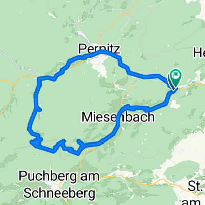
Overview
About this route
- -:--
- Duration
- 15 km
- Distance
- 556 m
- Ascent
- 537 m
- Descent
- ---
- Avg. speed
- ---
- Max. altitude
Route quality
Waytypes & surfaces along the route
Waytypes
Quiet road
4.5 km
(30 %)
Road
3.6 km
(24 %)
Surfaces
Paved
13.6 km
(91 %)
Unpaved
0.6 km
(4 %)
Asphalt
13.5 km
(90 %)
Ground
0.6 km
(4 %)
Continue with Bikemap
Use, edit, or download this cycling route
You would like to ride Auf der Höh or customize it for your own trip? Here is what you can do with this Bikemap route:
Free features
- Save this route as favorite or in collections
- Copy & plan your own version of this route
- Sync your route with Garmin or Wahoo
Premium features
Free trial for 3 days, or one-time payment. More about Bikemap Premium.
- Navigate this route on iOS & Android
- Export a GPX / KML file of this route
- Create your custom printout (try it for free)
- Download this route for offline navigation
Discover more Premium features.
Get Bikemap PremiumFrom our community
Other popular routes starting in Waldegg
 Radrunde von Waldegg nach Wiener Neustadt
- Distance
- 24.6 km
- Ascent
- 75 m
- Descent
- 193 m
- Location
- Waldegg, Lower Austria, Austria
 Warm up Frühling 2010
- Distance
- 45.1 km
- Ascent
- 760 m
- Descent
- 786 m
- Location
- Waldegg, Lower Austria, Austria
 GT Öhler Schutzhaus Original
- Distance
- 46.5 km
- Ascent
- 1,659 m
- Descent
- 1,662 m
- Location
- Waldegg, Lower Austria, Austria
 Erster Tandemflug
- Distance
- 5.2 km
- Ascent
- 126 m
- Descent
- 647 m
- Location
- Waldegg, Lower Austria, Austria
 Hohe Wand-Sopron
- Distance
- 71.4 km
- Ascent
- 205 m
- Descent
- 884 m
- Location
- Waldegg, Lower Austria, Austria
 Hernstein
- Distance
- 42.4 km
- Ascent
- 393 m
- Descent
- 393 m
- Location
- Waldegg, Lower Austria, Austria
 Oed 5 nach Rathausplatz 1, Leobersdorf
- Distance
- 24.4 km
- Ascent
- 28 m
- Descent
- 211 m
- Location
- Waldegg, Lower Austria, Austria
 Rund um die Hohe Wand 1
- Distance
- 45.8 km
- Ascent
- 662 m
- Descent
- 662 m
- Location
- Waldegg, Lower Austria, Austria
Open it in the app