
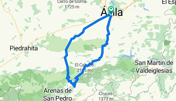
Ávila - Navalmoral - Serranillos - El Pico - Menga
A cycling route starting in Ávila, Castille and León, Spain.
Overview
About this route
Mountain passes: Navalmoral (1514 m). Serranillos (1575 m). El Pico (1352 m). Menga (1564 m).
- -:--
- Duration
- 141.7 km
- Distance
- 2,985 m
- Ascent
- 2,858 m
- Descent
- ---
- Avg. speed
- 1,572 m
- Max. altitude
Route quality
Waytypes & surfaces along the route
Waytypes
Cycleway
49.6 km
(35 %)
Track
18.4 km
(13 %)
Surfaces
Paved
114.7 km
(81 %)
Unpaved
12.7 km
(9 %)
Asphalt
114.7 km
(81 %)
Unpaved (undefined)
5.7 km
(4 %)
Route highlights
Points of interest along the route
Point of interest after 17.4 km
Puerto de Navalmoral (1514 mts)
Point of interest after 57.2 km
Puerto de Serranillos (1575 mts).
Point of interest after 85.6 km
Puerto del Pico (1352 mts)
Point of interest after 102.7 km
Puerto de Menga (1564 mts)
Continue with Bikemap
Use, edit, or download this cycling route
You would like to ride Ávila - Navalmoral - Serranillos - El Pico - Menga or customize it for your own trip? Here is what you can do with this Bikemap route:
Free features
- Save this route as favorite or in collections
- Copy & plan your own version of this route
- Split it into stages to create a multi-day tour
- Sync your route with Garmin or Wahoo
Premium features
Free trial for 3 days, or one-time payment. More about Bikemap Premium.
- Navigate this route on iOS & Android
- Export a GPX / KML file of this route
- Create your custom printout (try it for free)
- Download this route for offline navigation
Discover more Premium features.
Get Bikemap PremiumFrom our community
Other popular routes starting in Ávila
 Ávila - Navalmoral - Serranillos - El Pico - Menga
- Distance
- 141.7 km
- Ascent
- 2,985 m
- Descent
- 2,858 m
- Location
- Ávila, Castille and León, Spain
 Days 10 &11 Avila - Palazuelos de Eresma, Segovia (via Soto del Real) CORRECT
- Distance
- 208.4 km
- Ascent
- 4,293 m
- Descent
- 4,420 m
- Location
- Ávila, Castille and León, Spain
 Ávila - Cruz de Hierro - La Lancha - Arrebatacapas - Boquerón - Ávila
- Distance
- 123.3 km
- Ascent
- 1,649 m
- Descent
- 1,653 m
- Location
- Ávila, Castille and León, Spain
 Ávila - Cruz de Hierro - La Lancha - Arrebatacapas - Boquerón - Ávila
- Distance
- 141.3 km
- Ascent
- 1,835 m
- Descent
- 1,835 m
- Location
- Ávila, Castille and León, Spain
 Navalmoral, Barraco, Arrebatacapas y Boqueron
- Distance
- 105.8 km
- Ascent
- 1,435 m
- Descent
- 1,435 m
- Location
- Ávila, Castille and León, Spain
 Avila - Balbarda - Avila
- Distance
- 55.1 km
- Ascent
- 508 m
- Descent
- 523 m
- Location
- Ávila, Castille and León, Spain
 Porteras
- Distance
- 34.5 km
- Ascent
- 2,306 m
- Descent
- 2,228 m
- Location
- Ávila, Castille and León, Spain
 Avila - Pto. Boqueron - Pto. La Paramera - Pto. Navalmoral - Navaluenga
- Distance
- 57 km
- Ascent
- 529 m
- Descent
- 884 m
- Location
- Ávila, Castille and León, Spain
Open it in the app