

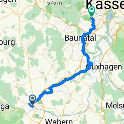
Rothhelmhausner Runde
A cycling route starting in Fritzlar, Hesse, Germany.
Overview
About this route
- -:--
- Duration
- 23.9 km
- Distance
- 231 m
- Ascent
- 230 m
- Descent
- ---
- Avg. speed
- ---
- Max. altitude
Continue with Bikemap
Use, edit, or download this cycling route
You would like to ride Rothhelmhausner Runde or customize it for your own trip? Here is what you can do with this Bikemap route:
Free features
- Save this route as favorite or in collections
- Copy & plan your own version of this route
- Sync your route with Garmin or Wahoo
Premium features
Free trial for 3 days, or one-time payment. More about Bikemap Premium.
- Navigate this route on iOS & Android
- Export a GPX / KML file of this route
- Create your custom printout (try it for free)
- Download this route for offline navigation
Discover more Premium features.
Get Bikemap PremiumFrom our community
Other popular routes starting in Fritzlar
 Fritzlarer-Frühstücks-Runde
- Distance
- 43.7 km
- Ascent
- 353 m
- Descent
- 355 m
- Location
- Fritzlar, Hesse, Germany
 FZ-Bad Wild.-Bad Zwest.-Kleinenglis-FZ
- Distance
- 56.9 km
- Ascent
- 453 m
- Descent
- 453 m
- Location
- Fritzlar, Hesse, Germany
 Bonifatiusstraße nach Espenauer Straße
- Distance
- 59.3 km
- Ascent
- 472 m
- Descent
- 457 m
- Location
- Fritzlar, Hesse, Germany
 Edersee
- Distance
- 22.8 km
- Ascent
- 190 m
- Descent
- 115 m
- Location
- Fritzlar, Hesse, Germany
 Rund um das obere Holz
- Distance
- 27.5 km
- Ascent
- 145 m
- Descent
- 147 m
- Location
- Fritzlar, Hesse, Germany
 Rothhelmhausner Runde
- Distance
- 23.9 km
- Ascent
- 231 m
- Descent
- 230 m
- Location
- Fritzlar, Hesse, Germany
 Harler Hügel
- Distance
- 28 km
- Ascent
- 315 m
- Descent
- 294 m
- Location
- Fritzlar, Hesse, Germany
 Domplatz nach Hermann-Mattern-Straße
- Distance
- 34.2 km
- Ascent
- 307 m
- Descent
- 301 m
- Location
- Fritzlar, Hesse, Germany
Open it in the app