

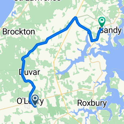
french shore 1
A cycling route starting in Alberton, Prince Edward Island, Canada.
Overview
About this route
- -:--
- Duration
- 71.4 km
- Distance
- 164 m
- Ascent
- 161 m
- Descent
- ---
- Avg. speed
- ---
- Max. altitude
Continue with Bikemap
Use, edit, or download this cycling route
You would like to ride french shore 1 or customize it for your own trip? Here is what you can do with this Bikemap route:
Free features
- Save this route as favorite or in collections
- Copy & plan your own version of this route
- Sync your route with Garmin or Wahoo
Premium features
Free trial for 3 days, or one-time payment. More about Bikemap Premium.
- Navigate this route on iOS & Android
- Export a GPX / KML file of this route
- Create your custom printout (try it for free)
- Download this route for offline navigation
Discover more Premium features.
Get Bikemap PremiumFrom our community
Other popular routes starting in Alberton
 alberton cape north retuen
- Distance
- 74.6 km
- Ascent
- 121 m
- Descent
- 120 m
- Location
- Alberton, Prince Edward Island, Canada
 Bloomfield/Tignish
- Distance
- 79.5 km
- Ascent
- 170 m
- Descent
- 165 m
- Location
- Alberton, Prince Edward Island, Canada
 alberton tidnish retuen
- Distance
- 43.3 km
- Ascent
- 118 m
- Descent
- 117 m
- Location
- Alberton, Prince Edward Island, Canada
 From O'Leary to Alberton
- Distance
- 27.9 km
- Ascent
- 67 m
- Descent
- 83 m
- Location
- Alberton, Prince Edward Island, Canada
 Trans Canada Trail (PEI): Confederation Trail Main - Alberton to Souris
- Distance
- 251.8 km
- Ascent
- 908 m
- Descent
- 880 m
- Location
- Alberton, Prince Edward Island, Canada
 northern tip PEI
- Distance
- 144.8 km
- Ascent
- 178 m
- Descent
- 181 m
- Location
- Alberton, Prince Edward Island, Canada
 De Albion Street 66, Alberton à Albion Street 66, Alberton
- Distance
- 12.1 km
- Ascent
- 54 m
- Descent
- 33 m
- Location
- Alberton, Prince Edward Island, Canada
 PEI 2019
- Distance
- 269 km
- Ascent
- 389 m
- Descent
- 372 m
- Location
- Alberton, Prince Edward Island, Canada
Open it in the app