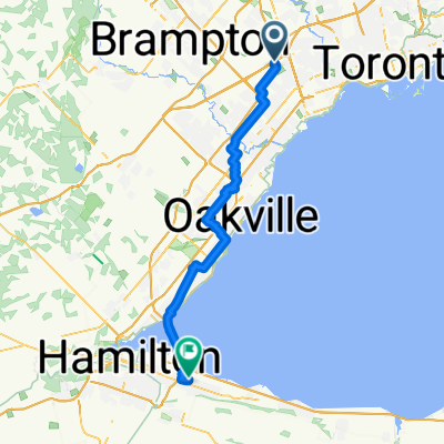
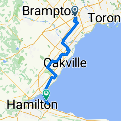
Marie Curtis Park Mississauga-West and East Islands Toronto
A cycling route starting in Etobicoke, Ontario, Canada.
Overview
About this route
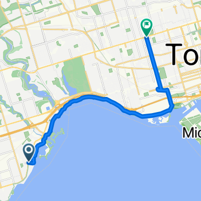
From Marie Curtis Park in Mississauga, Ontario to West and East Islands in Toronto riding on Lakeshore Boulevard and the Water Front Trail.
- -:--
- Duration
- 22.4 km
- Distance
- 67 m
- Ascent
- 67 m
- Descent
- ---
- Avg. speed
- ---
- Avg. speed
Route quality
Waytypes & surfaces along the route
Waytypes
Pedestrian area
9 km
(40 %)
Path
6.3 km
(28 %)
Surfaces
Paved
10.4 km
(46 %)
Unpaved
2.8 km
(13 %)
Asphalt
8.9 km
(40 %)
Gravel
1.6 km
(7 %)
Continue with Bikemap
Use, edit, or download this cycling route
You would like to ride Marie Curtis Park Mississauga-West and East Islands Toronto or customize it for your own trip? Here is what you can do with this Bikemap route:
Free features
- Save this route as favorite or in collections
- Copy & plan your own version of this route
- Sync your route with Garmin or Wahoo
Premium features
Free trial for 3 days, or one-time payment. More about Bikemap Premium.
- Navigate this route on iOS & Android
- Export a GPX / KML file of this route
- Create your custom printout (try it for free)
- Download this route for offline navigation
Discover more Premium features.
Get Bikemap PremiumFrom our community
Other popular routes starting in Etobicoke
- Malton GO to Union Via West Humber River Trial and High Park Zoo
- Distance
- 43.5 km
- Ascent
- 285 m
- Descent
- 366 m
- Location
- Etobicoke, Ontario, Canada
- Old Mill Return Via Humber River, Duck Pond, Centennial Park Conservatory, Etobicoke Creek, Lakeshore
- Distance
- 39.8 km
- Ascent
- 320 m
- Descent
- 303 m
- Location
- Etobicoke, Ontario, Canada
- bolton Kleinberg Loop
- Distance
- 78.2 km
- Ascent
- 244 m
- Descent
- 244 m
- Location
- Etobicoke, Ontario, Canada
- humber river trail
- Distance
- 33 km
- Ascent
- 585 m
- Descent
- 465 m
- Location
- Etobicoke, Ontario, Canada
- Relaxed route in Toronto
- Distance
- 16.9 km
- Ascent
- 0 m
- Descent
- 0 m
- Location
- Etobicoke, Ontario, Canada
- Day1_Airport Toronto to Mississauga
- Distance
- 15.4 km
- Ascent
- 74 m
- Descent
- 85 m
- Location
- Etobicoke, Ontario, Canada
- Easy ride in Mississauga
- Distance
- 13.7 km
- Ascent
- 33 m
- Descent
- 12 m
- Location
- Etobicoke, Ontario, Canada
- Humber - Eg - Royal York
- Distance
- 14.4 km
- Ascent
- 93 m
- Descent
- 93 m
- Location
- Etobicoke, Ontario, Canada
Open it in the app