- 72.4 km
- 67 m
- 242 m
- Ohorn, Saxony, Germany
Röderradroute 1. Teil bergig
A cycling route starting in Ohorn, Saxony, Germany.
Overview
About this route
I rode a trekking bike and despite some rain, managed well through the few unpaved sections. The terrain is, except for two climbs, to be described as hilly. Arrival at Pulsnitz by train from Dresden Hbf. Return from Radeburg leisurely with the Lösnitzdackel.
- -:--
- Duration
- 59.3 km
- Distance
- 220 m
- Ascent
- 338 m
- Descent
- ---
- Avg. speed
- ---
- Max. altitude
created this 8 years ago
Route quality
Waytypes & surfaces along the route
Waytypes
Quiet road
27.3 km
(46 %)
Road
10.1 km
(17 %)
Surfaces
Paved
35 km
(59 %)
Unpaved
7.1 km
(12 %)
Asphalt
33.8 km
(57 %)
Ground
3.6 km
(6 %)
Continue with Bikemap
Use, edit, or download this cycling route
You would like to ride Röderradroute 1. Teil bergig or customize it for your own trip? Here is what you can do with this Bikemap route:
Free features
- Save this route as favorite or in collections
- Copy & plan your own version of this route
- Sync your route with Garmin or Wahoo
Premium features
Free trial for 3 days, or one-time payment. More about Bikemap Premium.
- Navigate this route on iOS & Android
- Export a GPX / KML file of this route
- Create your custom printout (try it for free)
- Download this route for offline navigation
Discover more Premium features.
Get Bikemap PremiumFrom our community
Other popular routes starting in Ohorn
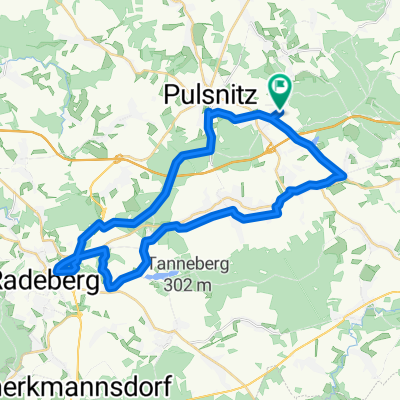
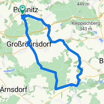
- radeln an der Pulsnitz
- Ohorn -Radeberg
- 35.5 km
- 316 m
- 318 m
- Ohorn, Saxony, Germany
- Alte Großröhrsdorfer Straße 8, Pulsnitz nach Arnsdorfer Straße 1, Großröhrsdorf
- 10 km
- 85 m
- 101 m
- Ohorn, Saxony, Germany
- Day 5 V2B
- 150.1 km
- 647 m
- 921 m
- Ohorn, Saxony, Germany
- Pulsnitz-Rammenau-Massenei-Oberlichtenau
- 55.1 km
- 367 m
- 393 m
- Ohorn, Saxony, Germany
- Pulsnitzer Alpen und Seiffersdorfer Tal
- 78 km
- 694 m
- 786 m
- Ohorn, Saxony, Germany
- Konsumring nach Konsumring
- 30.4 km
- 284 m
- 333 m
- Ohorn, Saxony, Germany
- Röderradroute 1. Teil bergig
- 59.3 km
- 220 m
- 338 m
- Ohorn, Saxony, Germany
Open it in the app


