

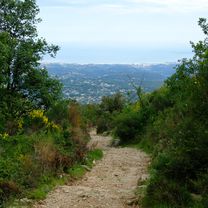
dag-4-chabauda-St Vallier de Thiey
A cycling route starting in Gilette, Provence-Alpes-Côte d'Azur Region, France.
Overview
About this route
- -:--
- Duration
- 56.2 km
- Distance
- 2,314 m
- Ascent
- 1,878 m
- Descent
- ---
- Avg. speed
- ---
- Max. altitude

Route highlights
Points of interest along the route
Point of interest after 45.1 km
camping st hubert dag 4
Point of interest after 56.2 km
camping dag 4 St Vallier de Thiey
Continue with Bikemap
Use, edit, or download this cycling route
You would like to ride dag-4-chabauda-St Vallier de Thiey or customize it for your own trip? Here is what you can do with this Bikemap route:
Free features
- Save this route as favorite or in collections
- Copy & plan your own version of this route
- Sync your route with Garmin or Wahoo
Premium features
Free trial for 3 days, or one-time payment. More about Bikemap Premium.
- Navigate this route on iOS & Android
- Export a GPX / KML file of this route
- Create your custom printout (try it for free)
- Download this route for offline navigation
Discover more Premium features.
Get Bikemap PremiumFrom our community
Other popular routes starting in Gilette
 dag-4-chabauda-St Vallier de Thiey
- Distance
- 56.2 km
- Ascent
- 2,314 m
- Descent
- 1,878 m
- Location
- Gilette, Provence-Alpes-Côte d'Azur Region, France
 Autour de Gilette
- Distance
- 39.4 km
- Ascent
- 899 m
- Descent
- 899 m
- Location
- Gilette, Provence-Alpes-Côte d'Azur Region, France
 Tour Estéron (raccourci Vescous)
- Distance
- 56.4 km
- Ascent
- 1,460 m
- Descent
- 1,464 m
- Location
- Gilette, Provence-Alpes-Côte d'Azur Region, France
 D17, Gilette à 350 Route du Collège, Saint-Martin-du-Var
- Distance
- 16 km
- Ascent
- 222 m
- Descent
- 454 m
- Location
- Gilette, Provence-Alpes-Côte d'Azur Region, France
 Itinéraire vers 931 Route du Cougnet, Briançonnet
- Distance
- 45.2 km
- Ascent
- 1,056 m
- Descent
- 395 m
- Location
- Gilette, Provence-Alpes-Côte d'Azur Region, France
 Paris Nice 22-roquestron-cagnes
- Distance
- 71.4 km
- Ascent
- 1,189 m
- Descent
- 1,512 m
- Location
- Gilette, Provence-Alpes-Côte d'Azur Region, France
 5573–5585 Route de Roquesteron, Gilette à 931 Route du Cougnet, Briançonnet
- Distance
- 45.2 km
- Ascent
- 1,090 m
- Descent
- 432 m
- Location
- Gilette, Provence-Alpes-Côte d'Azur Region, France
 Roquesteron - Nizza
- Distance
- 77.1 km
- Ascent
- 1,734 m
- Descent
- 2,024 m
- Location
- Gilette, Provence-Alpes-Côte d'Azur Region, France
Open it in the app