

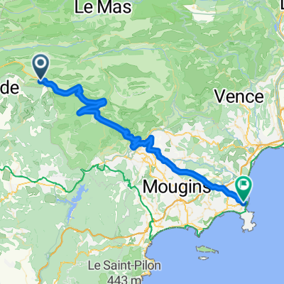
dag 5 - deel2-Seranon -Entrevaux
A cycling route starting in Saint-Vallier-de-Thiey, Provence-Alpes-Côte d'Azur Region, France.
Overview
About this route
- -:--
- Duration
- 44.8 km
- Distance
- 1,494 m
- Ascent
- 2,198 m
- Descent
- ---
- Avg. speed
- ---
- Max. altitude

Route highlights
Points of interest along the route
Point of interest after 0 km
camping saint vallier de thiey dag 4
Point of interest after 44.8 km
camping entreveaux (Le Brec) dag 5
Continue with Bikemap
Use, edit, or download this cycling route
You would like to ride dag 5 - deel2-Seranon -Entrevaux or customize it for your own trip? Here is what you can do with this Bikemap route:
Free features
- Save this route as favorite or in collections
- Copy & plan your own version of this route
- Sync your route with Garmin or Wahoo
Premium features
Free trial for 3 days, or one-time payment. More about Bikemap Premium.
- Navigate this route on iOS & Android
- Export a GPX / KML file of this route
- Create your custom printout (try it for free)
- Download this route for offline navigation
Discover more Premium features.
Get Bikemap PremiumFrom our community
Other popular routes starting in Saint-Vallier-de-Thiey
 CAILLE - COL DE BLEYNE
- Distance
- 70.9 km
- Ascent
- 905 m
- Descent
- 893 m
- Location
- Saint-Vallier-de-Thiey, Provence-Alpes-Côte d'Azur Region, France
 Long ride from St.-Vallier-de-Thiey to Grasse
- Distance
- 50.4 km
- Ascent
- 474 m
- Descent
- 1,074 m
- Location
- Saint-Vallier-de-Thiey, Provence-Alpes-Côte d'Azur Region, France
 06 N St Vallier Escra V10 34K 1550 Mt
- Distance
- 32.3 km
- Ascent
- 1,533 m
- Descent
- 1,537 m
- Location
- Saint-Vallier-de-Thiey, Provence-Alpes-Côte d'Azur Region, France
 Saint-Vallier-de-Thiey - Antibes
- Distance
- 56.5 km
- Ascent
- 19 m
- Descent
- 1,049 m
- Location
- Saint-Vallier-de-Thiey, Provence-Alpes-Côte d'Azur Region, France
 Montagne du thiey
- Distance
- 16.6 km
- Ascent
- 810 m
- Descent
- 810 m
- Location
- Saint-Vallier-de-Thiey, Provence-Alpes-Côte d'Azur Region, France
 saint valier
- Distance
- 17.2 km
- Ascent
- 565 m
- Descent
- 1,089 m
- Location
- Saint-Vallier-de-Thiey, Provence-Alpes-Côte d'Azur Region, France
 croix de cabris
- Distance
- 12.8 km
- Ascent
- 222 m
- Descent
- 225 m
- Location
- Saint-Vallier-de-Thiey, Provence-Alpes-Côte d'Azur Region, France
 Le long de l'ombre d'un château
- Distance
- 42.2 km
- Ascent
- 1,070 m
- Descent
- 1,067 m
- Location
- Saint-Vallier-de-Thiey, Provence-Alpes-Côte d'Azur Region, France
Open it in the app