

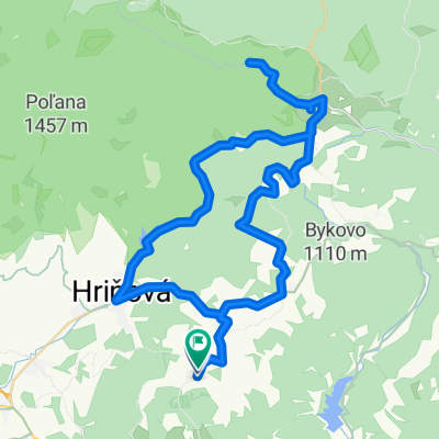
Z Kotmanovej cez Hrbáky, Fafáky, Kýpec a Hrnčiarky.
A cycling route starting in Hriňová, Banská Bystrica Region, Slovakia.
Overview
About this route
In Dobroč, next to the gardens, push up the steep section to the forest road that traverses the contour line towards Lovinobaňa. The forest road goes through the woods and can already be ridden in the saddle. At the intersection above Paprčkov, there is a short descent, a brief climb, and then another descent. In some spots, you get views of the Ružiná reservoir, the magnesite plant, and Mýtná. Before Lovinobaňa, turn off onto the blue marked trail (TZT) and continue climbing through Hrbáky to Horné Fafáky and Kýpec, where there are beautiful views. Continue towards Hrnčiarky. Enjoyable descent all the way to Kotmanová.
- -:--
- Duration
- 18.2 km
- Distance
- 535 m
- Ascent
- 533 m
- Descent
- ---
- Avg. speed
- ---
- Max. altitude

Route quality
Waytypes & surfaces along the route
Waytypes
Track
15.8 km
(87 %)
Road
1.8 km
(10 %)
Surfaces
Paved
1.8 km
(10 %)
Unpaved
16 km
(88 %)
Ground
11.5 km
(63 %)
Unpaved (undefined)
4 km
(22 %)
Continue with Bikemap
Use, edit, or download this cycling route
You would like to ride Z Kotmanovej cez Hrbáky, Fafáky, Kýpec a Hrnčiarky. or customize it for your own trip? Here is what you can do with this Bikemap route:
Free features
- Save this route as favorite or in collections
- Copy & plan your own version of this route
- Sync your route with Garmin or Wahoo
Premium features
Free trial for 3 days, or one-time payment. More about Bikemap Premium.
- Navigate this route on iOS & Android
- Export a GPX / KML file of this route
- Create your custom printout (try it for free)
- Download this route for offline navigation
Discover more Premium features.
Get Bikemap PremiumFrom our community
Other popular routes starting in Hriňová
 Farma pod Poľanou 01
- Distance
- 17.3 km
- Ascent
- 429 m
- Descent
- 436 m
- Location
- Hriňová, Banská Bystrica Region, Slovakia
 Okolo Ružinej
- Distance
- 8 km
- Ascent
- 94 m
- Descent
- 91 m
- Location
- Hriňová, Banská Bystrica Region, Slovakia
 Divín-Budiná-Vrchdobroč-Kotmanová-Divín
- Distance
- 45.4 km
- Ascent
- 1,291 m
- Descent
- 1,291 m
- Location
- Hriňová, Banská Bystrica Region, Slovakia
 Školská do Partizánska
- Distance
- 46.7 km
- Ascent
- 291 m
- Descent
- 336 m
- Location
- Hriňová, Banská Bystrica Region, Slovakia
 Hrinova-Polana_odPrednej-peso
- Distance
- 26.1 km
- Ascent
- 987 m
- Descent
- 987 m
- Location
- Hriňová, Banská Bystrica Region, Slovakia
 Kokava Haj - okruh
- Distance
- 6.4 km
- Ascent
- 413 m
- Descent
- 419 m
- Location
- Hriňová, Banská Bystrica Region, Slovakia
 Podpoľanie - okruh pod Poľanou
- Distance
- 61 km
- Ascent
- 1,033 m
- Descent
- 1,036 m
- Location
- Hriňová, Banská Bystrica Region, Slovakia
 Stredne náročná trasa
- Distance
- 24.5 km
- Ascent
- 858 m
- Descent
- 855 m
- Location
- Hriňová, Banská Bystrica Region, Slovakia
Open it in the app