

Panoramaroute um den Starnberger See
A cycling route starting in Tutzing, Bavaria, Germany.
Overview
About this route
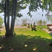
Von der Tutzinger Brahmspromenade aus startet die Tour um den See. In Richtung Norden kann man vor der Feldafinger Bucht die Aussicht auf die Roseninsel genießen, bevor man südlich von Starnberg die Staatsstraße befährt. Entlang des Ostufers ist auf der Strandpromenade weniger los, und dem Uferverlauf folgend gelangt man nach das Dorf Bernried, das von zwei wunderschönen Parks umrahmt wird. Leicht vom Ufer abweichend geht es auf die Ilkahöhe, von der man einen tollen Blick auf den Starnberger See und die Alpenkette hat. Nun ist Tutzing nicht mehr weit, und über einige Hügel und 15 weitere Kilometer erreicht man Herrsching am Ammersee.
- -:--
- Duration
- 64.4 km
- Distance
- 303 m
- Ascent
- 368 m
- Descent
- ---
- Avg. speed
- ---
- Max. altitude

Continue with Bikemap
Use, edit, or download this cycling route
You would like to ride Panoramaroute um den Starnberger See or customize it for your own trip? Here is what you can do with this Bikemap route:
Free features
- Save this route as favorite or in collections
- Copy & plan your own version of this route
- Sync your route with Garmin or Wahoo
Premium features
Free trial for 3 days, or one-time payment. More about Bikemap Premium.
- Navigate this route on iOS & Android
- Export a GPX / KML file of this route
- Create your custom printout (try it for free)
- Download this route for offline navigation
Discover more Premium features.
Get Bikemap PremiumFrom our community
Other popular routes starting in Tutzing
 Fünfseenrunde
- Distance
- 68.7 km
- Ascent
- 560 m
- Descent
- 558 m
- Location
- Tutzing, Bavaria, Germany
 Untitled route
- Distance
- 83.1 km
- Ascent
- 929 m
- Descent
- 720 m
- Location
- Tutzing, Bavaria, Germany
 Von Tutzing um den Ammersee
- Distance
- 68.3 km
- Ascent
- 533 m
- Descent
- 505 m
- Location
- Tutzing, Bavaria, Germany
 Tutzin - Schongau - Tutzing
- Distance
- 104 km
- Ascent
- 633 m
- Descent
- 633 m
- Location
- Tutzing, Bavaria, Germany
 Waldschmidtstraße nach Seepromenade
- Distance
- 13.4 km
- Ascent
- 336 m
- Descent
- 402 m
- Location
- Tutzing, Bavaria, Germany
 TU03_Ilkahöhe
- Distance
- 9.5 km
- Ascent
- 133 m
- Descent
- 131 m
- Location
- Tutzing, Bavaria, Germany
 S-Bhf. Tutzing nach Aussichtslokal Ilkahöhe
- Distance
- 15.1 km
- Ascent
- 167 m
- Descent
- 161 m
- Location
- Tutzing, Bavaria, Germany
 TU13_Schloss-Possenhofen
- Distance
- 9.7 km
- Ascent
- 52 m
- Descent
- 60 m
- Location
- Tutzing, Bavaria, Germany
Open it in the app