

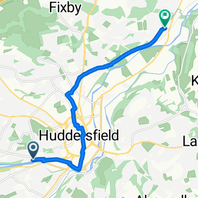
sb - oakwellhall
A cycling route starting in Huddersfield, England, United Kingdom.
Overview
About this route
start summerset bridge / st andrews road / leeds road / deighton / bradley / onto green way / huddersfield road / hartshead / heartshead moor / scholes / cleckheaton / gomersal / oakwell return oakwell / gomersal / cleckheaton / liversage / ravensthorpe / greenway / bradley / leeds road / sb / hm.
- -:--
- Duration
- 51.1 km
- Distance
- 434 m
- Ascent
- 306 m
- Descent
- ---
- Avg. speed
- ---
- Max. altitude
Route quality
Waytypes & surfaces along the route
Waytypes
Quiet road
12.3 km
(24 %)
Cycleway
9.7 km
(19 %)
Surfaces
Paved
18.4 km
(36 %)
Asphalt
18.4 km
(36 %)
Undefined
32.7 km
(64 %)
Continue with Bikemap
Use, edit, or download this cycling route
You would like to ride sb - oakwellhall or customize it for your own trip? Here is what you can do with this Bikemap route:
Free features
- Save this route as favorite or in collections
- Copy & plan your own version of this route
- Sync your route with Garmin or Wahoo
Premium features
Free trial for 3 days, or one-time payment. More about Bikemap Premium.
- Navigate this route on iOS & Android
- Export a GPX / KML file of this route
- Create your custom printout (try it for free)
- Download this route for offline navigation
Discover more Premium features.
Get Bikemap PremiumFrom our community
Other popular routes starting in Huddersfield
 Thurstonland Hills
- Distance
- 31.3 km
- Ascent
- 479 m
- Descent
- 474 m
- Location
- Huddersfield, England, United Kingdom
 Brian Robinson Challenge, 17 April 2011
- Distance
- 118 km
- Ascent
- 1,473 m
- Descent
- 1,470 m
- Location
- Huddersfield, England, United Kingdom
 Huddersfield to Mirfield and back
- Distance
- 23.5 km
- Ascent
- 69 m
- Descent
- 179 m
- Location
- Huddersfield, England, United Kingdom
 sb - oakwellhall
- Distance
- 51.1 km
- Ascent
- 434 m
- Descent
- 306 m
- Location
- Huddersfield, England, United Kingdom
 Route in Huddersfield
- Distance
- 7.2 km
- Ascent
- 40 m
- Descent
- 63 m
- Location
- Huddersfield, England, United Kingdom
 Thurstonland Hills
- Distance
- 31.3 km
- Ascent
- 437 m
- Descent
- 432 m
- Location
- Huddersfield, England, United Kingdom
 Huddersfield to Amsterdam
- Distance
- 725.4 km
- Ascent
- 58 m
- Descent
- 123 m
- Location
- Huddersfield, England, United Kingdom
 Route from Huddersfield
- Distance
- 1.5 km
- Ascent
- 43 m
- Descent
- 0 m
- Location
- Huddersfield, England, United Kingdom
Open it in the app