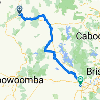
Nanango, Kumbia, Nanango
A cycling route starting in Yarraman, Queensland, Australia.
Overview
About this route
Hard climb at 25km, quick breakfast at Kumbia, easier return trip, coffee at Nanango
- -:--
- Duration
- 77.2 km
- Distance
- 557 m
- Ascent
- 557 m
- Descent
- ---
- Avg. speed
- ---
- Avg. speed
Route quality
Waytypes & surfaces along the route
Waytypes
Quiet road
49.5 km
(64 %)
Busy road
26.4 km
(34 %)
Surfaces
Paved
38.3 km
(50 %)
Unpaved
20.6 km
(27 %)
Asphalt
38 km
(49 %)
Unpaved (undefined)
20.6 km
(27 %)
Continue with Bikemap
Use, edit, or download this cycling route
You would like to ride Nanango, Kumbia, Nanango or customize it for your own trip? Here is what you can do with this Bikemap route:
Free features
- Save this route as favorite or in collections
- Copy & plan your own version of this route
- Sync your route with Garmin or Wahoo
Premium features
Free trial for 3 days, or one-time payment. More about Bikemap Premium.
- Navigate this route on iOS & Android
- Export a GPX / KML file of this route
- Create your custom printout (try it for free)
- Download this route for offline navigation
Discover more Premium features.
Get Bikemap PremiumFrom our community
Other popular routes starting in Yarraman
- Yarraman to Linville Summer ride
- Distance
- 40.9 km
- Ascent
- 147 m
- Descent
- 442 m
- Location
- Yarraman, Queensland, Australia
- BVRT Yarraman to Wanora
- Distance
- 145.5 km
- Ascent
- 402 m
- Descent
- 766 m
- Location
- Yarraman, Queensland, Australia
- Yarraman to Moore
- Distance
- 47.7 km
- Ascent
- 199 m
- Descent
- 510 m
- Location
- Yarraman, Queensland, Australia
- BVRT-support vehicle route
- Distance
- 168.6 km
- Ascent
- 486 m
- Descent
- 845 m
- Location
- Yarraman, Queensland, Australia
- GB5 Section 05
- Distance
- 42.7 km
- Ascent
- 468 m
- Descent
- 382 m
- Location
- Yarraman, Queensland, Australia
- BVRT Blackbutt - Yarraman
- Distance
- 18.9 km
- Ascent
- 169 m
- Descent
- 159 m
- Location
- Yarraman, Queensland, Australia
- Nanango to Dalby, Queensland, Australia
- Distance
- 123.1 km
- Ascent
- 657 m
- Descent
- 664 m
- Location
- Yarraman, Queensland, Australia
- Scott Street, Benarkin to D'Aguilar Highway 5809, Gilla
- Distance
- 9.3 km
- Ascent
- 64 m
- Descent
- 64 m
- Location
- Yarraman, Queensland, Australia
Open it in the app