
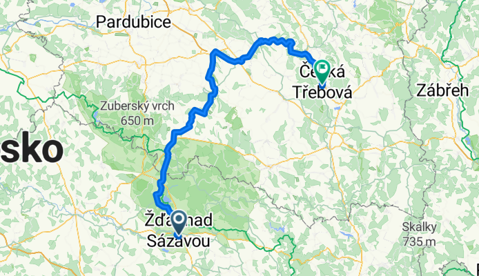
Žďár nad Sázavou - Hlinsko - Vysoké Mýto - Choceň - Ústí nad Orlicí - Česká Třebová
A cycling route starting in Zdar, Kraj Vysočina, Czechia.
Overview
About this route
Žďár nad Sázavou - Hlinsko - Vysoké Mýto - Choceň - Ústí nad Orlicí - Česká Třebová
- -:--
- Duration
- 113.8 km
- Distance
- 527 m
- Ascent
- 725 m
- Descent
- ---
- Avg. speed
- ---
- Max. altitude

Route quality
Waytypes & surfaces along the route
Waytypes
Road
40.3 km
(35 %)
Cycleway
21.9 km
(19 %)
Surfaces
Paved
52 km
(46 %)
Unpaved
2.4 km
(2 %)
Asphalt
50.7 km
(45 %)
Gravel
1.9 km
(2 %)
Continue with Bikemap
Use, edit, or download this cycling route
You would like to ride Žďár nad Sázavou - Hlinsko - Vysoké Mýto - Choceň - Ústí nad Orlicí - Česká Třebová or customize it for your own trip? Here is what you can do with this Bikemap route:
Free features
- Save this route as favorite or in collections
- Copy & plan your own version of this route
- Split it into stages to create a multi-day tour
- Sync your route with Garmin or Wahoo
Premium features
Free trial for 3 days, or one-time payment. More about Bikemap Premium.
- Navigate this route on iOS & Android
- Export a GPX / KML file of this route
- Create your custom printout (try it for free)
- Download this route for offline navigation
Discover more Premium features.
Get Bikemap PremiumFrom our community
Other popular routes starting in Zdar
 Ze Žďáru okolo Sázavy, do Přibyslavi a přes Polnou zpět
- Distance
- 68.2 km
- Ascent
- 528 m
- Descent
- 529 m
- Location
- Zdar, Kraj Vysočina, Czechia
 Žďár nad Sázavou - Hlinsko - Vysoké Mýto - Choceň - Ústí nad Orlicí - Česká Třebová
- Distance
- 113.8 km
- Ascent
- 527 m
- Descent
- 725 m
- Location
- Zdar, Kraj Vysočina, Czechia
 Žďár - Peperek - Račín - Žlábek - Ranská jezírka - Staré Ransko - Řeka - Hluboká - Polnička - Žďár
- Distance
- 45.7 km
- Ascent
- 579 m
- Descent
- 549 m
- Location
- Zdar, Kraj Vysočina, Czechia
 Trénink na zítřek
- Distance
- 44.8 km
- Ascent
- 455 m
- Descent
- 451 m
- Location
- Zdar, Kraj Vysočina, Czechia
 Prague - Brno, Euro Velo No 7, 13, 9 and 4! Etapp 6
- Distance
- 139.8 km
- Ascent
- 1,444 m
- Descent
- 1,838 m
- Location
- Zdar, Kraj Vysočina, Czechia
 Red-Bull - Vodka tour, swih 3
- Distance
- 22.4 km
- Ascent
- 253 m
- Descent
- 250 m
- Location
- Zdar, Kraj Vysočina, Czechia
 Rožná - Náměšť nad Oslavou
- Distance
- 64.6 km
- Ascent
- 726 m
- Descent
- 923 m
- Location
- Zdar, Kraj Vysočina, Czechia
 Večerní projížďka do Veselí
- Distance
- 13 km
- Ascent
- 119 m
- Descent
- 119 m
- Location
- Zdar, Kraj Vysočina, Czechia
Open it in the app