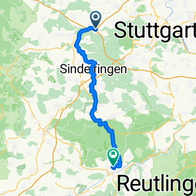
Leo - Sifi - Renningen - Leo
A cycling route starting in Leonberg, Baden-Wurttemberg, Germany.
Overview
About this route
From the Leonberg youth center through Warmbronn and Magstadt to Sindelfingen. From there to Maichingen and then Magstadt on to Renningen. Then back to Leonberg to the Leobad (swim once across the pool) and then back to the youth center.
- -:--
- Duration
- 30.7 km
- Distance
- 404 m
- Ascent
- 415 m
- Descent
- ---
- Avg. speed
- 512 m
- Max. altitude
Route quality
Waytypes & surfaces along the route
Waytypes
Track
13.5 km
(44 %)
Quiet road
7.1 km
(23 %)
Surfaces
Paved
23.9 km
(78 %)
Unpaved
3.1 km
(10 %)
Asphalt
23.6 km
(77 %)
Gravel
2.8 km
(9 %)
Continue with Bikemap
Use, edit, or download this cycling route
You would like to ride Leo - Sifi - Renningen - Leo or customize it for your own trip? Here is what you can do with this Bikemap route:
Free features
- Save this route as favorite or in collections
- Copy & plan your own version of this route
- Sync your route with Garmin or Wahoo
Premium features
Free trial for 3 days, or one-time payment. More about Bikemap Premium.
- Navigate this route on iOS & Android
- Export a GPX / KML file of this route
- Create your custom printout (try it for free)
- Download this route for offline navigation
Discover more Premium features.
Get Bikemap PremiumFrom our community
Other popular routes starting in Leonberg
- Enztal und Schwarzwald
- Distance
- 102.9 km
- Ascent
- 1,122 m
- Descent
- 1,122 m
- Location
- Leonberg, Baden-Wurttemberg, Germany
- Leo - Sifi - Renningen - Leo
- Distance
- 30.7 km
- Ascent
- 404 m
- Descent
- 415 m
- Location
- Leonberg, Baden-Wurttemberg, Germany
- Rutesheim - Schillerhöhe
- Distance
- 27.2 km
- Ascent
- 304 m
- Descent
- 304 m
- Location
- Leonberg, Baden-Wurttemberg, Germany
- Rund um Leonberg
- Distance
- 39.6 km
- Ascent
- 415 m
- Descent
- 415 m
- Location
- Leonberg, Baden-Wurttemberg, Germany
- Sabine Leonberg
- Distance
- 49.3 km
- Ascent
- 480 m
- Descent
- 480 m
- Location
- Leonberg, Baden-Wurttemberg, Germany
- Leonberg Tour de Natur 2008-Final
- Distance
- 35.6 km
- Ascent
- 335 m
- Descent
- 278 m
- Location
- Leonberg, Baden-Wurttemberg, Germany
- Über die Feinau
- Distance
- 27.4 km
- Ascent
- 326 m
- Descent
- 326 m
- Location
- Leonberg, Baden-Wurttemberg, Germany
- Meine ersten fast 50 Kilometer
- Distance
- 49.2 km
- Ascent
- 523 m
- Descent
- 486 m
- Location
- Leonberg, Baden-Wurttemberg, Germany
Open it in the app