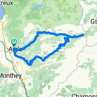
47° Nord Tour de Suisse Etappe 4
A cycling route starting in Aigle, Canton of Vaud, Switzerland.
Overview
About this route
Von Aigle aus folgen wir der Veloland Schweiz Route No 4 nach Montbovon und wechseln anschliessend auf die No 9 bis nach Château-d'Oex. Die Route steigt gleich hinter dem Ort steil durch die Weinberge empor
- -:--
- Duration
- 63.7 km
- Distance
- 1,423 m
- Ascent
- 938 m
- Descent
- ---
- Avg. speed
- ---
- Avg. speed
Route photos
Route quality
Waytypes & surfaces along the route
Waytypes
Quiet road
45 km
(71 %)
Busy road
10 km
(16 %)
Surfaces
Paved
45.8 km
(72 %)
Unpaved
0.6 km
(<1 %)
Asphalt
26.8 km
(42 %)
Paved (undefined)
11.5 km
(18 %)
Route highlights
Points of interest along the route
Point of interest after 13 km
Tunnel Der Tunnel ist nur einspurig und ohne Beleuchtung er darf jeweils in der ersten viertelstunde befahren werden ( 9.00-9.15 10.00-10.15 usw) wer später in den Tunnel einfährt muss mit Gegenverkehr rechnen und entsprechend vorsichtig sein, es gibt ausweichstellen.
Continue with Bikemap
Use, edit, or download this cycling route
You would like to ride 47° Nord Tour de Suisse Etappe 4 or customize it for your own trip? Here is what you can do with this Bikemap route:
Free features
- Save this route as favorite or in collections
- Copy & plan your own version of this route
- Sync your route with Garmin or Wahoo
Premium features
Free trial for 3 days, or one-time payment. More about Bikemap Premium.
- Navigate this route on iOS & Android
- Export a GPX / KML file of this route
- Create your custom printout (try it for free)
- Download this route for offline navigation
Discover more Premium features.
Get Bikemap PremiumFrom our community
Other popular routes starting in Aigle
- 2016_tt_e9
- Distance
- 50 km
- Ascent
- 175 m
- Descent
- 201 m
- Location
- Aigle, Canton of Vaud, Switzerland
- Stage 1, Aigle - Meiringen
- Distance
- 151.4 km
- Ascent
- 1,498 m
- Descent
- 1,326 m
- Location
- Aigle, Canton of Vaud, Switzerland
- 2014-T12-Aigle-Moudon
- Distance
- 51.8 km
- Ascent
- 668 m
- Descent
- 552 m
- Location
- Aigle, Canton of Vaud, Switzerland
- Etapa 078B (Aigle - Divonne les Bains)
- Distance
- 117.3 km
- Ascent
- 1,328 m
- Descent
- 1,164 m
- Location
- Aigle, Canton of Vaud, Switzerland
- Complete Alpine Tour
- Distance
- 506.5 km
- Ascent
- 5,081 m
- Descent
- 5,093 m
- Location
- Aigle, Canton of Vaud, Switzerland
- Aigle-Mosses-Pillon-Croix-Aigle CLONED FROM ROUTE 222631
- Distance
- 105.6 km
- Ascent
- 2,213 m
- Descent
- 2,213 m
- Location
- Aigle, Canton of Vaud, Switzerland
- Rundfahrt mit Aussicht
- Distance
- 71.3 km
- Ascent
- 1,942 m
- Descent
- 1,943 m
- Location
- Aigle, Canton of Vaud, Switzerland
- Aigle 1/7
- Distance
- 169.5 km
- Ascent
- 2,802 m
- Descent
- 2,015 m
- Location
- Aigle, Canton of Vaud, Switzerland