

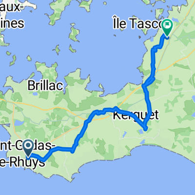
saint gildas - saint armel - 18km 30D+
A cycling route starting in Saint-Gildas-de-Rhuys, Brittany Region, France.
Overview
About this route
- -:--
- Duration
- 18.2 km
- Distance
- 65 m
- Ascent
- 67 m
- Descent
- ---
- Avg. speed
- ---
- Max. altitude

Route quality
Waytypes & surfaces along the route
Waytypes
Quiet road
8.9 km
(49 %)
Cycleway
5.5 km
(30 %)
Surfaces
Paved
6.2 km
(34 %)
Unpaved
3.3 km
(18 %)
Asphalt
6.2 km
(34 %)
Gravel
3.1 km
(17 %)
Continue with Bikemap
Use, edit, or download this cycling route
You would like to ride saint gildas - saint armel - 18km 30D+ or customize it for your own trip? Here is what you can do with this Bikemap route:
Free features
- Save this route as favorite or in collections
- Copy & plan your own version of this route
- Sync your route with Garmin or Wahoo
Premium features
Free trial for 3 days, or one-time payment. More about Bikemap Premium.
- Navigate this route on iOS & Android
- Export a GPX / KML file of this route
- Create your custom printout (try it for free)
- Download this route for offline navigation
Discover more Premium features.
Get Bikemap PremiumFrom our community
Other popular routes starting in Saint-Gildas-de-Rhuys
 De Route de Sarzeau 90, Saint-Gildas-de-Rhuys à Route de Sarzeau 90, Saint-Gildas-de-Rhuys
- Distance
- 25.4 km
- Ascent
- 227 m
- Descent
- 224 m
- Location
- Saint-Gildas-de-Rhuys, Brittany Region, France
 4 Route du Croizio, Saint-Gildas-de-Rhuys naar 4 Route du Croizio, Saint-Gildas-de-Rhuys
- Distance
- 14.2 km
- Ascent
- 285 m
- Descent
- 289 m
- Location
- Saint-Gildas-de-Rhuys, Brittany Region, France
 Tour presqu'île de Rhuys
- Distance
- 78.6 km
- Ascent
- 175 m
- Descent
- 175 m
- Location
- Saint-Gildas-de-Rhuys, Brittany Region, France
 saint gildas de rhuys / St Armel
- Distance
- 20.4 km
- Ascent
- 82 m
- Descent
- 104 m
- Location
- Saint-Gildas-de-Rhuys, Brittany Region, France
 Tour presqu'île de Rhuys II
- Distance
- 111.1 km
- Ascent
- 210 m
- Descent
- 210 m
- Location
- Saint-Gildas-de-Rhuys, Brittany Region, France
 Saint gildas de rhuys / Ile Quistinic
- Distance
- 45.7 km
- Ascent
- 164 m
- Descent
- 187 m
- Location
- Saint-Gildas-de-Rhuys, Brittany Region, France
 CX Presqu'ile de Rhuys
- Distance
- 54.3 km
- Ascent
- 140 m
- Descent
- 135 m
- Location
- Saint-Gildas-de-Rhuys, Brittany Region, France
 De Rue de Largueven 7065, Saint-Gildas-de-Rhuys à Rue Jean de la Fontaine 1, Sarzeau
- Distance
- 16.4 km
- Ascent
- 119 m
- Descent
- 102 m
- Location
- Saint-Gildas-de-Rhuys, Brittany Region, France
Open it in the app