
Monte Baldo Höhenstraße (Teil 1)
A cycling route starting in Mori, Trentino-Alto Adige, Italy.
Overview
About this route
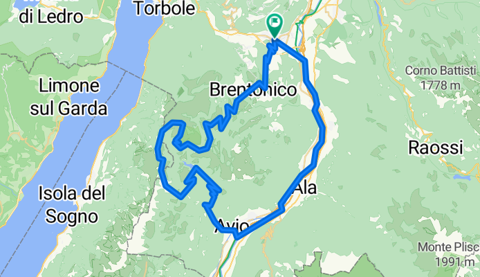
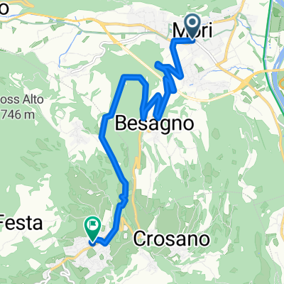
Mori-Besagno-Crosano-San Valentino-Avio-Pilcante-Serravalle on the Adige-Mori
- -:--
- Duration
- 67.1 km
- Distance
- 1,541 m
- Ascent
- 1,542 m
- Descent
- ---
- Avg. speed
- ---
- Max. altitude

Route quality
Waytypes & surfaces along the route
Waytypes
Road
38.9 km
(58 %)
Cycleway
12.7 km
(19 %)
Surfaces
Paved
61.7 km
(92 %)
Asphalt
61.7 km
(92 %)
Undefined
5.4 km
(8 %)
Continue with Bikemap
Use, edit, or download this cycling route
You would like to ride Monte Baldo Höhenstraße (Teil 1) or customize it for your own trip? Here is what you can do with this Bikemap route:
Free features
- Save this route as favorite or in collections
- Copy & plan your own version of this route
- Sync your route with Garmin or Wahoo
Premium features
Free trial for 3 days, or one-time payment. More about Bikemap Premium.
- Navigate this route on iOS & Android
- Export a GPX / KML file of this route
- Create your custom printout (try it for free)
- Download this route for offline navigation
Discover more Premium features.
Get Bikemap PremiumFrom our community
Other popular routes starting in Mori
 Recording from 26 ottobre 13:55
- Distance
- 68.4 km
- Ascent
- 191 m
- Descent
- 269 m
- Location
- Mori, Trentino-Alto Adige, Italy
 Giro d'Italia 2013 - 18. Mori - Polsa (crono individuale)
- Distance
- 19.4 km
- Ascent
- 1,089 m
- Descent
- 79 m
- Location
- Mori, Trentino-Alto Adige, Italy
 Mori - P.sso Monte Faè - Val di Gresta - Loppio - Mori
- Distance
- 24.6 km
- Ascent
- 914 m
- Descent
- 915 m
- Location
- Mori, Trentino-Alto Adige, Italy
 10-Rovereto-Torbole (Lago della Garda)
- Distance
- 14.4 km
- Ascent
- 140 m
- Descent
- 239 m
- Location
- Mori, Trentino-Alto Adige, Italy
 monte baldo
- Distance
- 114.8 km
- Ascent
- 2,646 m
- Descent
- 2,642 m
- Location
- Mori, Trentino-Alto Adige, Italy
 Mori - Brentonico
- Distance
- 8.4 km
- Ascent
- 623 m
- Descent
- 121 m
- Location
- Mori, Trentino-Alto Adige, Italy
 Bayern - Rom 3. Etappe
- Distance
- 128.4 km
- Ascent
- 240 m
- Descent
- 496 m
- Location
- Mori, Trentino-Alto Adige, Italy
 Loppio, Mori (Moor in Tirol) nach Via Panoramica, Malcesine
- Distance
- 50.7 km
- Ascent
- 1,736 m
- Descent
- 1,675 m
- Location
- Mori, Trentino-Alto Adige, Italy
Open it in the app