
Rund durchs Steyr- und Kremstal
A cycling route starting in Pfarrkirchen bei Bad Hall, Upper Austria, Austria.
Overview
About this route
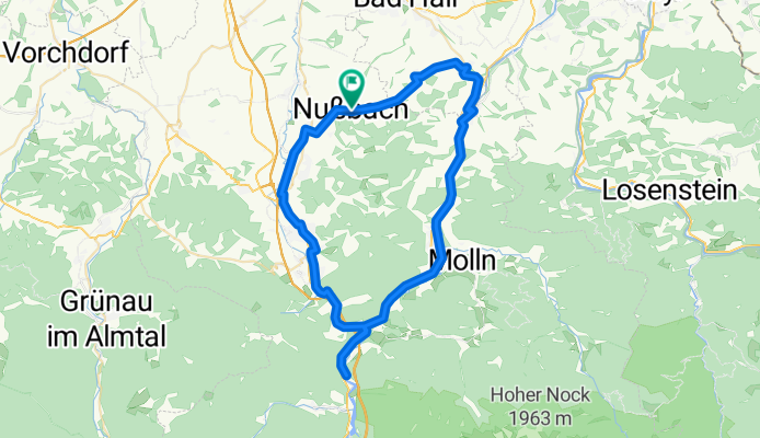
Start and finish: Nußbach municipal square We cycle to Waldneukirchen on the main road – caution is advised – and then via a side road to the centre of Grünburg. There we join the Steyr Valley cycle path. On the path we continue to Klaus, where we ride on open roads to the lake restaurant. Then back onto the Kremstal cycle path from Steinwänd to Micheldorf. There we take the village route, continue to Kirchdorf, also on open roads, arriving from the south at Redtenbacherplatz. Next, alongside the federal and main roads, we pass through an underpass to reach the railway-side path, which we leave at Auern heading towards Jageredt/Nußbach. Then back on the main road – with a stop in Dauersdorf – towards Nußbach where we end our tour.
- -:--
- Duration
- 74.6 km
- Distance
- 374 m
- Ascent
- 374 m
- Descent
- ---
- Avg. speed
- ---
- Max. altitude
Route quality
Waytypes & surfaces along the route
Waytypes
Cycleway
27.6 km
(37 %)
Quiet road
20.1 km
(27 %)
Surfaces
Paved
41 km
(55 %)
Unpaved
0.7 km
(1 %)
Asphalt
35.8 km
(48 %)
Paved (undefined)
5.2 km
(7 %)
Route highlights
Points of interest along the route
Point of interest after 18.5 km
Messerermuseum Dorferneuerungspionier Steinbacher Advent
Point of interest after 22 km
ehemalige Pappenfabrik Bierdeckelerzeugung
Point of interest after 27.9 km
´Rinnende Mauer Betriebsgelände & Zentrale der Fa. Bernegger
Point of interest after 32 km
Blick auf die Steyr
Point of interest after 35.7 km
Blick auf den Steyrdurchbruch
Continue with Bikemap
Use, edit, or download this cycling route
You would like to ride Rund durchs Steyr- und Kremstal or customize it for your own trip? Here is what you can do with this Bikemap route:
Free features
- Save this route as favorite or in collections
- Copy & plan your own version of this route
- Sync your route with Garmin or Wahoo
Premium features
Free trial for 3 days, or one-time payment. More about Bikemap Premium.
- Navigate this route on iOS & Android
- Export a GPX / KML file of this route
- Create your custom printout (try it for free)
- Download this route for offline navigation
Discover more Premium features.
Get Bikemap PremiumFrom our community
Other popular routes starting in Pfarrkirchen bei Bad Hall
 Steyrtalrunde - Richtung Ost
- Distance
- 51.3 km
- Ascent
- 345 m
- Descent
- 338 m
- Location
- Pfarrkirchen bei Bad Hall, Upper Austria, Austria
 Von Pogmunkl nach Altpernstein
- Distance
- 14.4 km
- Ascent
- 595 m
- Descent
- 267 m
- Location
- Pfarrkirchen bei Bad Hall, Upper Austria, Austria
 Waldkugelbahn in Nußbach
- Distance
- 1.5 km
- Ascent
- 96 m
- Descent
- 8 m
- Location
- Pfarrkirchen bei Bad Hall, Upper Austria, Austria
 August-Rundfahrt
- Distance
- 252.2 km
- Ascent
- 3,130 m
- Descent
- 3,097 m
- Location
- Pfarrkirchen bei Bad Hall, Upper Austria, Austria
 Unbenannte Route
- Distance
- 29.4 km
- Ascent
- 246 m
- Descent
- 407 m
- Location
- Pfarrkirchen bei Bad Hall, Upper Austria, Austria
 Frühjahrstour Dauersdorf - über die Höhe nach Altpernstein - im Kremstalretour
- Distance
- 35.5 km
- Ascent
- 562 m
- Descent
- 557 m
- Location
- Pfarrkirchen bei Bad Hall, Upper Austria, Austria
 Hausrunde
- Distance
- 35.2 km
- Ascent
- 384 m
- Descent
- 382 m
- Location
- Pfarrkirchen bei Bad Hall, Upper Austria, Austria
 Weissen Sattel
- Distance
- 33.7 km
- Ascent
- 671 m
- Descent
- 637 m
- Location
- Pfarrkirchen bei Bad Hall, Upper Austria, Austria
Open it in the app