
bretagna tappa incontro
A cycling route starting in Paimpont, Brittany Region, France.
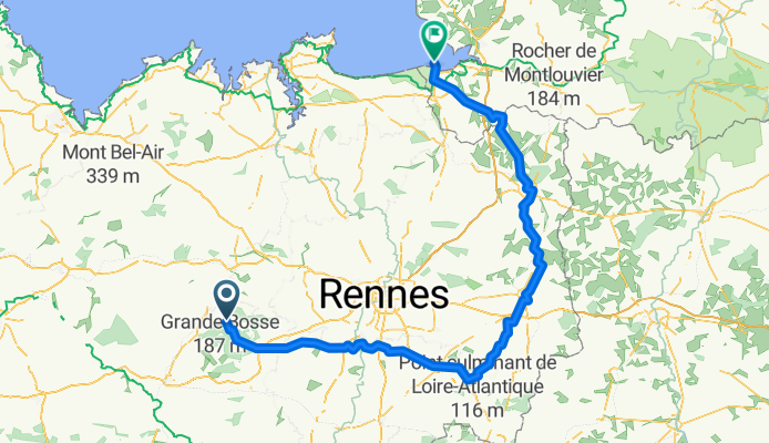
Overview
About this route
10/08 partenza in bici mattina da concoret per vitre
11/08 da vitre a fourges
12/08 da fourges a ducey (possibile incontro)
- -:--
- Duration
- 188.6 km
- Distance
- 479 m
- Ascent
- 534 m
- Descent
- ---
- Avg. speed
- ---
- Max. altitude

Route quality
Waytypes & surfaces along the route
Waytypes
Road
88.7 km
(47 %)
Quiet road
49.7 km
(26 %)
Surfaces
Paved
95.6 km
(51 %)
Unpaved
5.2 km
(3 %)
Asphalt
91 km
(48 %)
Loose gravel
4.9 km
(3 %)
Route highlights
Points of interest along the route
Photo after 76.5 km
dolmen
Bike service after 107.1 km
Accommodation after 108.8 km
camping municipal de vitree
Accommodation after 140 km
camping municipal de Paron
Bike service after 144.8 km
Point of interest after 163.2 km
cimitero americano
Accommodation after 184.5 km
camping aux pomier O°O
Accommodation after 186.2 km
camping du mont saint michelle
Continue with Bikemap
Use, edit, or download this cycling route
You would like to ride bretagna tappa incontro or customize it for your own trip? Here is what you can do with this Bikemap route:
Free features
- Save this route as favorite or in collections
- Copy & plan your own version of this route
- Split it into stages to create a multi-day tour
- Sync your route with Garmin or Wahoo
Premium features
Free trial for 3 days, or one-time payment. More about Bikemap Premium.
- Navigate this route on iOS & Android
- Export a GPX / KML file of this route
- Create your custom printout (try it for free)
- Download this route for offline navigation
Discover more Premium features.
Get Bikemap PremiumFrom our community
Other popular routes starting in Paimpont
 2016 July day 2 Paimpont to Port Saint Pere (Nantes) 122km
- Distance
- 122.3 km
- Ascent
- 338 m
- Descent
- 482 m
- Location
- Paimpont, Brittany Region, France
 Paseo rápido en
- Distance
- 11.9 km
- Ascent
- 145 m
- Descent
- 142 m
- Location
- Paimpont, Brittany Region, France
 15/05* A- PAIMPONT/ROCHEFORT EN TERRE,ESTRADAS PEQUENAS SEM CICLOVIA/05*- PAIMPONT/ROCHEFORT EN TERRE,ESTRADAS PEQUENAS SEM CICLOVIA 49,16 KM
- Distance
- 49.1 km
- Ascent
- 360 m
- Descent
- 459 m
- Location
- Paimpont, Brittany Region, France
 Paimpont nach 1 Esplanade de Brocéliande, Paimpont
- Distance
- 4.8 km
- Ascent
- 27 m
- Descent
- 103 m
- Location
- Paimpont, Brittany Region, France
 2 Rue des Forges, Paimpont nach 108 Le Tertre, Paimpont
- Distance
- 3.4 km
- Ascent
- 66 m
- Descent
- 8 m
- Location
- Paimpont, Brittany Region, France
 Grand tour de Brocéliande
- Distance
- 39.4 km
- Ascent
- 894 m
- Descent
- 895 m
- Location
- Paimpont, Brittany Region, France
 15/05*B- PAIMPONT/ROCHEFORT EN TERRE 63
- Distance
- 62.8 km
- Ascent
- 285 m
- Descent
- 386 m
- Location
- Paimpont, Brittany Region, France
 bretagna tappa incontro
- Distance
- 188.6 km
- Ascent
- 479 m
- Descent
- 534 m
- Location
- Paimpont, Brittany Region, France
Open it in the app