
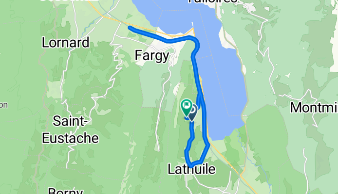
bike tour through Lathuile
A cycling route starting in Doussard, Auvergne-Rhône-Alpes, France.
Overview
About this route
Vanaf camping les Fontaines stukje fietsroute langs lac de Annect
- -:--
- Duration
- 15.2 km
- Distance
- 99 m
- Ascent
- 88 m
- Descent
- ---
- Avg. speed
- ---
- Max. altitude
Route quality
Waytypes & surfaces along the route
Waytypes
Cycleway
10.8 km
(71 %)
Quiet road
4.1 km
(27 %)
Surfaces
Paved
14.9 km
(98 %)
Asphalt
14.9 km
(98 %)
Undefined
0.4 km
(2 %)
Continue with Bikemap
Use, edit, or download this cycling route
You would like to ride bike tour through Lathuile or customize it for your own trip? Here is what you can do with this Bikemap route:
Free features
- Save this route as favorite or in collections
- Copy & plan your own version of this route
- Sync your route with Garmin or Wahoo
Premium features
Free trial for 3 days, or one-time payment. More about Bikemap Premium.
- Navigate this route on iOS & Android
- Export a GPX / KML file of this route
- Create your custom printout (try it for free)
- Download this route for offline navigation
Discover more Premium features.
Get Bikemap PremiumFrom our community
Other popular routes starting in Doussard
 Col de Aravis
- Distance
- 46.9 km
- Ascent
- 1,462 m
- Descent
- 460 m
- Location
- Doussard, Auvergne-Rhône-Alpes, France
 StEustache_47k_700m
- Distance
- 48.4 km
- Ascent
- 617 m
- Descent
- 617 m
- Location
- Doussard, Auvergne-Rhône-Alpes, France
 Saint-Jorioz-Cols Foclaz-Croix Fry-Aravis 105km-2100m
- Distance
- 104.8 km
- Ascent
- 2,770 m
- Descent
- 2,770 m
- Location
- Doussard, Auvergne-Rhône-Alpes, France
 LakeAnnecy_39k_280m
- Distance
- 39.9 km
- Ascent
- 235 m
- Descent
- 235 m
- Location
- Doussard, Auvergne-Rhône-Alpes, France
 Gravel en Bauges 1
- Distance
- 73.7 km
- Ascent
- 2,641 m
- Descent
- 2,643 m
- Location
- Doussard, Auvergne-Rhône-Alpes, France
 Col de la Forclaz de Montmin
- Distance
- 31.5 km
- Ascent
- 748 m
- Descent
- 746 m
- Location
- Doussard, Auvergne-Rhône-Alpes, France
 forclaz essai
- Distance
- 23.5 km
- Ascent
- 713 m
- Descent
- 728 m
- Location
- Doussard, Auvergne-Rhône-Alpes, France
 Ali Ride July 5 2015 long course
- Distance
- 77.1 km
- Ascent
- 1,527 m
- Descent
- 1,527 m
- Location
- Doussard, Auvergne-Rhône-Alpes, France
Open it in the app