

ojinu
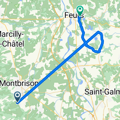
A cycling route starting in Lézigneux, Auvergne-Rhône-Alpes, France.
Overview
About this route
iiiiiiiiiiiiiiiiii
- -:--
- Duration
- 177.8 km
- Distance
- 3,241 m
- Ascent
- 2,802 m
- Descent
- ---
- Avg. speed
- ---
- Max. altitude
Route quality
Waytypes & surfaces along the route
Waytypes
Road
81.8 km
(46 %)
Quiet road
23.1 km
(13 %)
Surfaces
Paved
74.7 km
(42 %)
Unpaved
8.9 km
(5 %)
Asphalt
74.7 km
(42 %)
Ground
5.3 km
(3 %)
Continue with Bikemap
Use, edit, or download this cycling route
You would like to ride ojinu or customize it for your own trip? Here is what you can do with this Bikemap route:
Free features
- Save this route as favorite or in collections
- Copy & plan your own version of this route
- Split it into stages to create a multi-day tour
- Sync your route with Garmin or Wahoo
Premium features
Free trial for 3 days, or one-time payment. More about Bikemap Premium.
- Navigate this route on iOS & Android
- Export a GPX / KML file of this route
- Create your custom printout (try it for free)
- Download this route for offline navigation
Discover more Premium features.
Get Bikemap PremiumFrom our community
Other popular routes starting in Lézigneux
 7. St Antieme to Cunlhat
- Distance
- 52.4 km
- Ascent
- 723 m
- Descent
- 961 m
- Location
- Lézigneux, Auvergne-Rhône-Alpes, France
 CROIX de l'HOMME MORT, por Montbrison
- Distance
- 14.6 km
- Ascent
- 760 m
- Descent
- 0 m
- Location
- Lézigneux, Auvergne-Rhône-Alpes, France
 ojinu
ojinu- Distance
- 177.8 km
- Ascent
- 3,241 m
- Descent
- 2,802 m
- Location
- Lézigneux, Auvergne-Rhône-Alpes, France
 AlBienne 2011 Stage 7 Montbrison - Craponne s/Arzon
- Distance
- 52 km
- Ascent
- 948 m
- Descent
- 427 m
- Location
- Lézigneux, Auvergne-Rhône-Alpes, France
 C055-Saint-Jean-Soleymieux-Jouanzecq
- Distance
- 25.8 km
- Ascent
- 1,549 m
- Descent
- 2,302 m
- Location
- Lézigneux, Auvergne-Rhône-Alpes, France
 100 cols 4
- Distance
- 89.8 km
- Ascent
- 1,119 m
- Descent
- 1,623 m
- Location
- Lézigneux, Auvergne-Rhône-Alpes, France
 BARACUCHET, por Saint Anthème
- Distance
- 7.1 km
- Ascent
- 366 m
- Descent
- 34 m
- Location
- Lézigneux, Auvergne-Rhône-Alpes, France
 De Impasse des Adrets à Rue Ampère
- Distance
- 40.1 km
- Ascent
- 43 m
- Descent
- 67 m
- Location
- Lézigneux, Auvergne-Rhône-Alpes, France
Open it in the app