

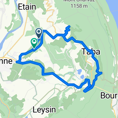
Jour 7
A cycling route starting in Yenne, Auvergne-Rhône-Alpes, France.
Overview
About this route
Billieme - Aeroport
- -:--
- Duration
- 91.2 km
- Distance
- 332 m
- Ascent
- 505 m
- Descent
- ---
- Avg. speed
- ---
- Max. altitude
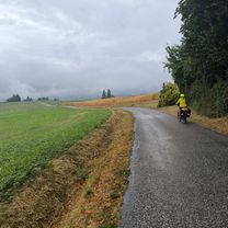
Route quality
Waytypes & surfaces along the route
Waytypes
Busy road
31.6 km
(35 %)
Quiet road
27.6 km
(30 %)
Surfaces
Paved
43.8 km
(48 %)
Unpaved
3.2 km
(4 %)
Asphalt
43.8 km
(48 %)
Gravel
2.1 km
(2 %)
Continue with Bikemap
Use, edit, or download this cycling route
You would like to ride Jour 7 or customize it for your own trip? Here is what you can do with this Bikemap route:
Free features
- Save this route as favorite or in collections
- Copy & plan your own version of this route
- Split it into stages to create a multi-day tour
- Sync your route with Garmin or Wahoo
Premium features
Free trial for 3 days, or one-time payment. More about Bikemap Premium.
- Navigate this route on iOS & Android
- Export a GPX / KML file of this route
- Create your custom printout (try it for free)
- Download this route for offline navigation
Discover more Premium features.
Get Bikemap PremiumFrom our community
Other popular routes starting in Yenne
 De Rue des Moulins à Chemin du Pailleret
- Distance
- 9.7 km
- Ascent
- 127 m
- Descent
- 227 m
- Location
- Yenne, Auvergne-Rhône-Alpes, France
 Третья поездка
- Distance
- 21.4 km
- Ascent
- 0 m
- Descent
- 0 m
- Location
- Yenne, Auvergne-Rhône-Alpes, France
 44. Camping des Lacs en Savoie - Genf - Vesenaz (Rechte Uferseite oberhalb von Genf
- Distance
- 93.6 km
- Ascent
- 558 m
- Descent
- 492 m
- Location
- Yenne, Auvergne-Rhône-Alpes, France
 Yenne - Dent du chat coté Bourget
- Distance
- 50.6 km
- Ascent
- 1,716 m
- Descent
- 1,716 m
- Location
- Yenne, Auvergne-Rhône-Alpes, France
 Yenne - Culoz, circuit 55 km
- Distance
- 55.5 km
- Ascent
- 538 m
- Descent
- 540 m
- Location
- Yenne, Auvergne-Rhône-Alpes, France
 Allevard - Yenne
- Distance
- 164.9 km
- Ascent
- 4,045 m
- Descent
- 3,772 m
- Location
- Yenne, Auvergne-Rhône-Alpes, France
 Chartreuse 21 - Etape 3 - Boucle Lacs du Bourget et d’Aiguebelette
- Distance
- 85.5 km
- Ascent
- 1,463 m
- Descent
- 1,463 m
- Location
- Yenne, Auvergne-Rhône-Alpes, France
 Park pri Seyssel - Brangues
- Distance
- 32.3 km
- Ascent
- 277 m
- Descent
- 355 m
- Location
- Yenne, Auvergne-Rhône-Alpes, France
Open it in the app