

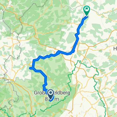
19_Schmitten Feldberg
A cycling route starting in Schmitten, Hesse, Germany.
Overview
About this route
From Schmitten to Feldberg - River valleys, castle ruins and viewing rocks
Requirements: Steep sections.
Suitable travel guide
- -:--
- Duration
- 20.2 km
- Distance
- 614 m
- Ascent
- 616 m
- Descent
- ---
- Avg. speed
- ---
- Max. altitude
Continue with Bikemap
Use, edit, or download this cycling route
You would like to ride 19_Schmitten Feldberg or customize it for your own trip? Here is what you can do with this Bikemap route:
Free features
- Save this route as favorite or in collections
- Copy & plan your own version of this route
- Sync your route with Garmin or Wahoo
Premium features
Free trial for 3 days, or one-time payment. More about Bikemap Premium.
- Navigate this route on iOS & Android
- Export a GPX / KML file of this route
- Create your custom printout (try it for free)
- Download this route for offline navigation
Discover more Premium features.
Get Bikemap PremiumFrom our community
Other popular routes starting in Schmitten
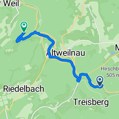
 Riedelbach - Burg Neuweilnau - Pferdskopfrunde
- Distance
- 15.2 km
- Ascent
- 548 m
- Descent
- 551 m
- Location
- Schmitten, Hesse, Germany
 Treisberg
- Distance
- 18.9 km
- Ascent
- 425 m
- Descent
- 469 m
- Location
- Schmitten, Hesse, Germany
 Feldberg Zurück
- Distance
- 65 km
- Ascent
- 625 m
- Descent
- 935 m
- Location
- Schmitten, Hesse, Germany
 Beidteweg 13, Schmitten nach Bassenheimer Straße 1, Schmitten
- Distance
- 7.2 km
- Ascent
- 352 m
- Descent
- 297 m
- Location
- Schmitten, Hesse, Germany
 Durchs malerische Weiltal zur Lahn und weiter nach Marburg
- Distance
- 141.8 km
- Ascent
- 1,477 m
- Descent
- 1,590 m
- Location
- Schmitten, Hesse, Germany
 Feldberg-Idstein
- Distance
- 20.1 km
- Ascent
- 109 m
- Descent
- 720 m
- Location
- Schmitten, Hesse, Germany
 Feldberg - Enkheim (Crossbike)
- Distance
- 35.4 km
- Ascent
- 99 m
- Descent
- 875 m
- Location
- Schmitten, Hesse, Germany
 Burg Weilstein, Weilrod nach Womberg
- Distance
- 7.6 km
- Ascent
- 184 m
- Descent
- 183 m
- Location
- Schmitten, Hesse, Germany
Open it in the app