
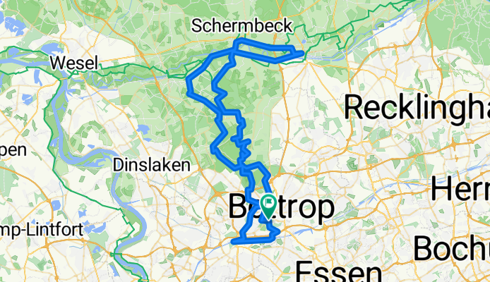
Gesundheitspark große Runde über Oberhausen, Golfplatz zur Fahradfähre Dorsten und zurück.
A cycling route starting in Bottrop, North Rhine-Westphalia, Germany.
Overview
About this route
The route runs mostly along very well-developed bike paths that require no advanced riding skills. There are a few small bumpy sections, but these pose no problem for any bike (road bikes are less suitable). In addition to truly beautiful forest and agricultural paths, the following highlights are along the route:
Ripshorst Arboretum, Zauberlehrling, Centro, Gasometer, Oberhausen Castle, Slinky Springs to Fame, Olga, Jacobi Golf Course, Bottrop City Pond, Grafenwald Recreational Area with Christmas Lake, Heidesee, Heidhofsee, Schwarze Heide Airfield, Wesel-Datteln Canal, Lippe with bicycle ferry, Schermbeck Field Railway, Hünxerwald Golf Club, Dinslaken Sträterei, Prosper Haniel spoil tip and mine.
- -:--
- Duration
- 91.8 km
- Distance
- 201 m
- Ascent
- 201 m
- Descent
- ---
- Avg. speed
- ---
- Max. altitude

Route quality
Waytypes & surfaces along the route
Waytypes
Track
31.2 km
(34 %)
Quiet road
28.5 km
(31 %)
Surfaces
Paved
32.1 km
(35 %)
Unpaved
43.2 km
(47 %)
Asphalt
31.2 km
(34 %)
Gravel
24.8 km
(27 %)
Route highlights
Points of interest along the route
Point of interest after 0 km
Startpunkt Bauernhof
Point of interest after 5.1 km
Gehölzgarten Ripshorst mit Zauberlehrling
Point of interest after 6.6 km
Sea Life Oberhausen
Point of interest after 6.9 km
Centro Oberhausen
Point of interest after 8.7 km
Schloß Oberhausen
Point of interest after 9.1 km
Slinky Springs to Fame Rehberger Brücke
Point of interest after 10.3 km
Gasometer Oberhausen
Drinking water after 22.8 km
Elke's Treff
Point of interest after 31 km
Heidhofsee
Continue with Bikemap
Use, edit, or download this cycling route
You would like to ride Gesundheitspark große Runde über Oberhausen, Golfplatz zur Fahradfähre Dorsten und zurück. or customize it for your own trip? Here is what you can do with this Bikemap route:
Free features
- Save this route as favorite or in collections
- Copy & plan your own version of this route
- Split it into stages to create a multi-day tour
- Sync your route with Garmin or Wahoo
Premium features
Free trial for 3 days, or one-time payment. More about Bikemap Premium.
- Navigate this route on iOS & Android
- Export a GPX / KML file of this route
- Create your custom printout (try it for free)
- Download this route for offline navigation
Discover more Premium features.
Get Bikemap PremiumFrom our community
Other popular routes starting in Bottrop
 Halde Haniel - östlicher Aufgang
- Distance
- 3.1 km
- Ascent
- 142 m
- Descent
- 54 m
- Location
- Bottrop, North Rhine-Westphalia, Germany
 Bottrop-Gladbeck-Polsum-Bottrop
- Distance
- 42.3 km
- Ascent
- 107 m
- Descent
- 105 m
- Location
- Bottrop, North Rhine-Westphalia, Germany
 Bottrop-Wesel-Dinslaken-Bottrop
- Distance
- 77.4 km
- Ascent
- 196 m
- Descent
- 198 m
- Location
- Bottrop, North Rhine-Westphalia, Germany
 Bottrop-Gladbeck-Polsum-Bottrop
- Distance
- 42.4 km
- Ascent
- 107 m
- Descent
- 105 m
- Location
- Bottrop, North Rhine-Westphalia, Germany
 Bottroperwald Rundfahrt 30km mit Restaurant
- Distance
- 35.2 km
- Ascent
- 109 m
- Descent
- 108 m
- Location
- Bottrop, North Rhine-Westphalia, Germany
 Bottrop-Telgte-100km
- Distance
- 100.8 km
- Ascent
- 165 m
- Descent
- 147 m
- Location
- Bottrop, North Rhine-Westphalia, Germany
 Sonntagmorgens.
- Distance
- 62.1 km
- Ascent
- 142 m
- Descent
- 127 m
- Location
- Bottrop, North Rhine-Westphalia, Germany
 Sturmshof nach Voßstraße
- Distance
- 14 km
- Ascent
- 237 m
- Descent
- 252 m
- Location
- Bottrop, North Rhine-Westphalia, Germany
Open it in the app