

VIA DELLE MALGHE NEL PARCO NAZIONALE DELLO STELVIO
A cycling route starting in San Bernardo, Trentino-Alto Adige, Italy.
Overview
About this route
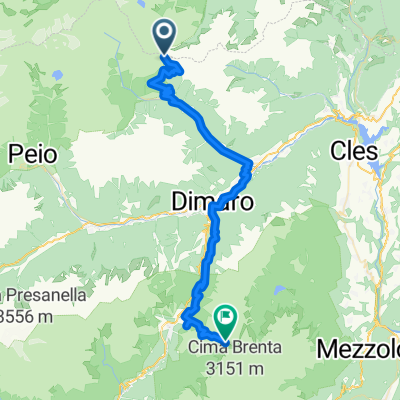
Fascinating itinerary in the heart of Val di Rabbi, passing among the alpine Malgas and the habitats of the deer in the Stelvio National Park. The route unfolds almost entirely in the forest, passing through areas of great faunistic and environmental interest as well as wide meadow zones from which breathtaking panoramas can be enjoyed. The ascent takes place on a compact dirt road while the descent features numerous technical sections of singletrack in the forest, passing near the famous Saent waterfalls.
From the church of San Bernardo, passing through the village square, you reach the locality of Poz; from here you climb on the right orographic side of the Rabbies stream on a comfortable dirt road up to the Pralongo Bridge in the typically alpine environment of Val di Rabbi. Staying on the same side, continuing beyond the bridge, the road becomes a well-beaten path that, alongside the “Ruaie” - one of the oldest hamlets of Rabbi - and the foaming stream, leads us to the Casna Bridge; from here you encounter a paved road parallel to provincial road no. 86 of Val di Rabbi which is followed up to the locality of Forni. Then turn left onto a dirt road between the first buildings of the locality of Bagni di Rabbi passing alongside the beautiful and ancient Venetian sawmill restored by the Stelvio National Park Consortium, up to the Terme di Rabbi (an interesting visit to the establishment with tasting of the ferruginous water; the discovery and use of the acidic waters date back to the late 1600s). From here the paved road continues in the direction of Plan for about 500 metres until, on the left, a dirt road is noticed that climbs with indications to Malga Cercen. The road detaches from the valley floor and gradually enters the fir forest with a significant slope and very compact surface; after a few kilometres the slope decreases entering the valley floor pastures of Val Cercen. Passing the locality of Fontanon (equipped area) following indications for Malga Cercen, while on the opposite slope some very suggestive paths lead to the Malgas Villar, Fassa and Monte Sole (they are among the survivors of the over 70 Malgas of the valley). The route is undulating and occasionally steepens with long steep stretches until reaching Malga Cercen Bassa. From here on the right the road becomes flatter until reaching Malga Vilar (2,020 m) located on the slope just above the wooded vegetation. Continuing towards Malga Fassa (2,057 m) across wide pastures and a steep gully along an easy path where it is necessary to push the MTB for about 20 minutes. Slightly beyond the Malga, which also has a road from the valley floor, one moves at the same altitude to Malga Monte Sole Alta (2,048 m), renowned for milk processing and the production of typical high mountain cheese. Following the road that descends to the valley floor, after two hairpin bends on the left indications for Malga Fratte Alta lead on a path that crosses in gentle descent the beautiful fir and larch forest. The Malga (1,857 m), abandoned for a long time, is located in an exceptionally panoramic position overlooking the Val di Rabbi and presents typical construction features of past times. The path descends zigzagging quickly through the pastures and enters the forest and, with a slope also considerable (some technical sections present), leads shortly to Malga Fratte Bassa (1,482 m) which, located on a dominant plateau, offers an excellent opportunity to admire the valley, the waterfalls, the high pastures and the often snowy peaks. A path crosses the pasture of the Malga on the north slope to then enter the forest; its route is wonderful, ideal for those who love mountain biking with technical passages, narrow switchbacks, short series of steps, fast balance sections, up to the Loc. Fontanino-Còler. The area, of particular faunistic and environmental importance due to the presence especially of deer and roe deer, requires silence and the utmost respect. From the locality of Fontanino, named for the presence of an evident source of ferruginous water, you climb on a dirt road to Malga Stablasolo (recommended tasting of milk and derivatives and typical salami). From here, following the indications for the Saent waterfalls, you overcome a steep earth slope, the remains of an imposing landslide, crossing a small stream and ascending again near the typical "Stablet" building. Here begins the pedestrian path to the waterfalls. Slightly lower in the direction of the waterfalls, a wide road with moderate slope crosses the Rabbies stream to become, on the opposite side, a path. You ride it with technical passages entering the dense forest until reconnecting to a dirt road that climbs slightly above the locality of Còler. The road descends quickly until it meets the paved road coming from Piazzola. You ride it through the open larch forest until close to the Loc. Somrabbi where, on the left, you take a forest road with some steep ups and downs that climbs along the high meadow areas of the valley surpassing the localities Serra, Cavallar and from here rapidly, through various ancient residential nuclei, you reach San Bernardo.
- -:--
- Duration
- 28.2 km
- Distance
- 1,271 m
- Ascent
- 1,271 m
- Descent
- ---
- Avg. speed
- ---
- Max. altitude

Continue with Bikemap
Use, edit, or download this cycling route
You would like to ride VIA DELLE MALGHE NEL PARCO NAZIONALE DELLO STELVIO or customize it for your own trip? Here is what you can do with this Bikemap route:
Free features
- Save this route as favorite or in collections
- Copy & plan your own version of this route
- Sync your route with Garmin or Wahoo
Premium features
Free trial for 3 days, or one-time payment. More about Bikemap Premium.
- Navigate this route on iOS & Android
- Export a GPX / KML file of this route
- Create your custom printout (try it for free)
- Download this route for offline navigation
Discover more Premium features.
Get Bikemap PremiumFrom our community
Other popular routes starting in San Bernardo
 Transalp 2015 Etappe 6 real.gpx
- Distance
- 49.5 km
- Ascent
- 1,648 m
- Descent
- 1,812 m
- Location
- San Bernardo, Trentino-Alto Adige, Italy
 Transalp Etappe 6
- Distance
- 43.6 km
- Ascent
- 1,739 m
- Descent
- 1,728 m
- Location
- San Bernardo, Trentino-Alto Adige, Italy
 Tag 5.
- Distance
- 76.5 km
- Ascent
- 1,093 m
- Descent
- 1,517 m
- Location
- San Bernardo, Trentino-Alto Adige, Italy
 ritorno migliore
- Distance
- 156.4 km
- Ascent
- 1,849 m
- Descent
- 2,276 m
- Location
- San Bernardo, Trentino-Alto Adige, Italy
 AlpenX2017_Etappe5
- Distance
- 49.5 km
- Ascent
- 1,887 m
- Descent
- 1,887 m
- Location
- San Bernardo, Trentino-Alto Adige, Italy
 Haselgruber Hütte - Rifugio Ghedina
- Distance
- 70.2 km
- Ascent
- 1,705 m
- Descent
- 3,017 m
- Location
- San Bernardo, Trentino-Alto Adige, Italy
 VIA DELLE MALGHE NEL PARCO NAZIONALE DELLO STELVIO
- Distance
- 28.2 km
- Ascent
- 1,271 m
- Descent
- 1,271 m
- Location
- San Bernardo, Trentino-Alto Adige, Italy
 12 part 5/6 st. gertraud >>> refugio graffer
- Distance
- 52.6 km
- Ascent
- 2,549 m
- Descent
- 1,713 m
- Location
- San Bernardo, Trentino-Alto Adige, Italy
Open it in the app