

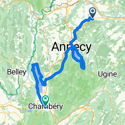
Plateau des Glieres Loop
A cycling route starting in Etaux, Auvergne-Rhône-Alpes, France.
Overview
About this route
Route is paved except for a couple of KMs crossing Col des Gleieres.
- -:--
- Duration
- 53.7 km
- Distance
- 1,848 m
- Ascent
- 1,674 m
- Descent
- ---
- Avg. speed
- 1,465 m
- Max. altitude

Route quality
Waytypes & surfaces along the route
Waytypes
Road
25.2 km
(47 %)
Quiet road
18.8 km
(35 %)
Surfaces
Paved
20.4 km
(38 %)
Unpaved
2.7 km
(5 %)
Asphalt
20.4 km
(38 %)
Loose gravel
1.6 km
(3 %)
Continue with Bikemap
Use, edit, or download this cycling route
You would like to ride Plateau des Glieres Loop or customize it for your own trip? Here is what you can do with this Bikemap route:
Free features
- Save this route as favorite or in collections
- Copy & plan your own version of this route
- Sync your route with Garmin or Wahoo
Premium features
Free trial for 3 days, or one-time payment. More about Bikemap Premium.
- Navigate this route on iOS & Android
- Export a GPX / KML file of this route
- Create your custom printout (try it for free)
- Download this route for offline navigation
Discover more Premium features.
Get Bikemap PremiumFrom our community
Other popular routes starting in Etaux
 630 Avenue Jean Jaurès, La Roche-sur-Foron à 240 Rue de Bourre, Saint-Laurent
- Distance
- 4.9 km
- Ascent
- 146 m
- Descent
- 30 m
- Location
- Etaux, Auvergne-Rhône-Alpes, France
 La roche -> Saleve
- Distance
- 55.8 km
- Ascent
- 1,105 m
- Descent
- 1,105 m
- Location
- Etaux, Auvergne-Rhône-Alpes, France
 Plateau des Glieres Loop
- Distance
- 53.1 km
- Ascent
- 1,739 m
- Descent
- 1,675 m
- Location
- Etaux, Auvergne-Rhône-Alpes, France
 2026: 17. La Roche sur Foron - Chambery
- Distance
- 159.9 km
- Ascent
- 2,516 m
- Descent
- 2,848 m
- Location
- Etaux, Auvergne-Rhône-Alpes, France
 La Roche Geneve par le Salève
- Distance
- 35.3 km
- Ascent
- 884 m
- Descent
- 1,025 m
- Location
- Etaux, Auvergne-Rhône-Alpes, France
 De Chemin de la Chapelle 383, La Roche-sur-Foron à Place Charles de Gaulle 7, Évian-les-Bains
- Distance
- 74.1 km
- Ascent
- 1,556 m
- Descent
- 2,173 m
- Location
- Etaux, Auvergne-Rhône-Alpes, France
 Plateau des Glieres Loop
- Distance
- 53.7 km
- Ascent
- 1,848 m
- Descent
- 1,674 m
- Location
- Etaux, Auvergne-Rhône-Alpes, France
 Relaxed route in Thorens-Glières
- Distance
- 39.2 km
- Ascent
- 715 m
- Descent
- 713 m
- Location
- Etaux, Auvergne-Rhône-Alpes, France
Open it in the app